ANDAMAN AND NICOBAR ISLANDS: DEVELOPMENT, SECURITY, AND ECOLOGY.
12 JUNE 2026
CONFERENCE REPORT
Report Prepared by- Trishala Sancheti, Research Fellow, India Foundation
TABLE OF CONTENTS
Inaugural Session
Welcome Address: Dr Ram Madhav, President, India Foundation
Special Address: Admiral D.K. Joshi, Lt Governor of Andaman and Nicobar Islands
Session 1: Sustainable Development, Community Governance, and Ecological Resilience in the Andaman and Nicobar Islands
Moderator: Capt. Alok Bansal, Executive Vice President, India Foundation
Prof. Jagdish Mukhi, Former Lieutenant Governor of Andaman and Nicobar Islands
Dr. Sanat Kaul, Former Chief Secretary, Andaman and Nicobar Islands
Mr. Shekhar Gupta, Journalist and Editor-in-Chief, The Print
Session 2: Andaman and Nicobar Islands as a Focal Point for Maritime Security and Regional Cooperation in the Indo-Pacific
Moderator: Ambassador Jaideep Mazumdar
Air Marshal P.K. Roy, Former Commander-in-Chief, Andaman and Nicobar Command
Ambassador Deepa Gopalan Wadhwa, Former Ambassador to Japan
Prof. C. Raja Mohan, Contributing Editor, Indian Express & Visiting Professor, NUS
Session 3: Great Nicobar Project – Balancing Ecology with Development and Strategic Preparation
Moderator: Ms. Rami Niranjan Desai
Dr. Sanjeev Ranjan, Former Secretary, Ministry of Shipping and Member, NCLT
Rear Admiral Girish Kumar Garg, Former Member, High-Powered Committee for Holistic Development of Great Nicobar
Island
INAUGURAL SESSION
Andaman and Nicobar Islands Security, Development and Ecology

The Andaman and Nicobar Islands constitute a vast and strategically significant part of India. The territory is nearly three times the size of Goa and several times larger than the National Capital Region. Yet, despite its size and importance, this significance remains insufficiently appreciated. One of the principal reasons for this, as Admiral Joshi recently noted in his article in The Indian Express, is that India has traditionally developed a continental mindset. We have not fully cultivated a maritime outlook towards our geography, security, and future. Ask any student about the southernmost point of India, and the answer will invariably be Kanyakumari. Yet India’s southernmost territory is actually Indira Point in the Nicobar Islands.
This fact is not merely geographical trivia. Indira Point lies less than 150 kilometres from one of the world’s most critical maritime chokepoints—the Malacca Strait. Every year, nearly 100,000 ships transit these waters. We are at the doorstep of one of the busiest sea lanes on the planet. The Andaman and Nicobar Islands therefore represent a region of immense economic, strategic, and developmental importance. Yet, for decades, their potential has not received adequate recognition. Today’s conference seeks to highlight the role this island chain can play in India’s economic growth, strategic posture, and maritime future. Throughout the day, we will examine the many opportunities this region offers.
Consider the economic dimension. Singapore began its journey as an independent nation in the mid-1960s. Today, it stands as one of the world’s premier transhipment hubs. Had we developed the Andaman and Nicobar Islands with the same vision several decades ago, they could well have emerged as an even larger transhipment centre, generating immense prosperity not only for the islands but for the entire nation. From a strategic perspective, the islands occupy a unique position at the heart of the Bay of Bengal and the eastern Indian Ocean. Nearly 80 per cent of the energy imports of countries such as China and Japan pass through the Strait of Malacca. The Andaman and Nicobar Islands provide India with an unparalleled vantage point for monitoring and securing these critical sea lanes. India’s only integrated tri-service command is located here. While this reflects the strategic value of the islands, the full potential of this location has not always received the attention it deserves.
The tourism potential is equally remarkable. Goa receives around ten million visitors each year. Bali attracts between fifteen and twenty million tourists annually. By comparison, the Andaman and Nicobar Islands currently receive fewer than one million visitors each year. While tourist arrivals have grown impressively—from around two lakh to nearly seven lakh in recent years— thanks to the efforts of Admiral Joshi and many others, the potential remains far greater.
A lack of understanding of the islands’ significance and a failure to recognise the opportunities they offer have prevented us from fully harnessing the potential of this crucial national asset. Fortunately, the Government of India is now placing renewed emphasis on the islands’ development. Tourism has expanded significantly, and major infrastructure projects are underway. Most notably, a large port-led development project, with investments of nearly ₹80,000 crore, is planned to transform the region into a major economic hub.
Naturally, such ambitious projects attract criticism. I sometimes remark that Jawaharlal Nehru was fortunate that the level of activism we witness today did not exist during his time; otherwise, projects such as the Bhakra Nangal Dam might never have been built. Every major infrastructure initiative today encounters opposition. While constructive criticism is always welcome, it is equally important to separate fact from misconception. The development project envisaged for the islands is not intended to destroy the ecology or threaten local communities. The facts tell a different story.
As Admiral Joshi has pointed out, less than 2% of the Andaman and Nicobar Islands’ total territory will be used for this project. The impact on forest cover is estimated to be less than 1.3 per cent. These figures must be viewed in context. India’s developmental opportunities are immense, and realising them requires a balanced approach that harmonises economic progress with environmental stewardship.
Today’s event was originally conceived as a single lecture by the Hon’ble Lieutenant Governor. However, we felt that a subject of such importance deserved a broader discussion encompassing its economic, strategic, environmental, and developmental dimensions. This led to the creation of this day-long conference. We are privileged to have with us Admiral Devendra Kumar Joshi, Lieutenant Governor of the Andaman and Nicobar Islands. Admiral Joshi served as Chief of the Naval Staff from 2012 to 2014 and has since devoted himself to the development and administration of this important Union Territory. We are also honoured to have several distinguished speakers joining us throughout the day, including former Lieutenant Governor Shri Jagdish Mukhi and other eminent experts.
I hope today’s deliberations will deepen understanding of one of India’s most valuable yet underappreciated strategic assets. With these words, I welcome all of you to this conference and invite His Excellency, Admiral D.K. Joshi, Lieutenant Governor of the Andaman and Nicobar Islands, to deliver his address.

My compliments to Dr Ram Madhav, President, India Foundation, for expanding the scope of this interaction over the entire day, spread across three very well-layered and very well structured sessions on a topic that he himself described as an island chain, the most critical to us, which, unfortunately, for several decades after independence, remained neglected—over the horizon, out of sight, out of mind, and its fullest potential was not realised. It is only in recent years that it has begun to move somewhat to the centre of mainstream discourse in the country. And towards that end, I think today’s session organised by the India Foundation would play a very critical role.
In this session, I aim to provide an overview that I hope will set the right backdrop for the three sessions that follow during the day. Therefore, I have structured this presentation as “Transformation Towards a Viksit Bharat.” To begin with, I would try to provide some perspective, some of which Dr Ram Madhav has himself provided, namely that to a vast majority of our countrymen, the Andaman Islands were hitherto seen as a set of islands close to Malaysia and Indonesia—small islands quite a distance from the east coast of India.
The fact that the Andaman and Nicobar Islands are within a handshake’s distance of Indonesia, Malaysia, Thailand, and Myanmar is a matter of geography. This group of 836 islands are small only in terms of population. Dr Ram Madhav provided some comparisons vis-à-vis some mainland states, with whom we share larger territory and real estate. But there again, it is not a homogeneous mass of one island of so many thousand square kilometres. It is 836 islands spread along a north-south axis of about 750 km.
A majority of these islands are not populated, but those at the extremities are. So even if it is a village of just about 100 residents on the northernmost island, the Ujjwala gas cylinder has to be provided there. Even if it is a tiny village of 200 residents on the southernmost island, your civil supplies, rudimentary healthcare, and basic schooling facilities have to be provided there. And therefore, the area over which your administrative reach, or the governance cover, has to extend is something like 49,000 square kilometres—bigger than half the states on the mainland.
Dr Ram Madhav also provided a few country-wise comparisons vis-à-vis Bali, among others. Let me attempt some more. If one were to ask which are the three hottest island tourism destinations in the Indian Ocean region, the answer would obviously be the Maldives, Mauritius, and theSeychelles. Now, if you total up the land area of all three countries, the Andaman and Nicobar Islands are four times that land area. That is one comparison. Vis-a-vis Singapore, just one of our islands, the southernmost island, the Great Nicobar Island, is one and a half times Singapore. The island of Little Andaman, also known as Hut Bay, which will be taken up for the next phase of development, is 0.9 the size of Singapore. So that is the perspective. We have one-third of the country’s EEZ and one-fourth of the coastline, which, in the maritime context, again puts into perspective where we stand. But all of it, unfortunately, remained neglected for the first six to seven-odd decades after independence.
From a historical perspective, between 1942 and 1946 the islands remained under Japanese rule for three and a half years. During that period, the provisional government was handed over to the INA, Netaji Subhash Chandra Bose’s Azad Hind Fauj. Netaji himself visited the island in 1943, hoisted the tricolour, and declared independence from British India. So the tricolour flew there for three and a half years before India actually gained independence. They issued their own postage stamps and currency, and for the most part during this period—the Second World War was in progress, and the Axis powers—Italy, Germany, Japan—extended diplomatic cover to the territory. But again, for about a year it reverted to British rule before India became independent in 1947. So this is one aspect in which it differs from mainland history.
Despite being widely regarded as a great tourist destination, the Islands had no five-star hotels across the entire archipelago. The first five-star hotel, the Taj Exotica, opened around 2020. There may have been an attempt to keep the Islands secluded for security reasons and out of concern for the tribal population. As a result, foreigners required a Restricted Area Permit (RAP), which they had to obtain in Delhi from various ministries, coordinated by the MHA. In fact, it was very difficult to obtain, so foreign traffic was close to nil. There were no such restrictions for Indians, but due to poor and rudimentary connectivity, most tourists would come only to Sri Vijaya Puram (Port Blair), Swaraj Dweep (Havelock Island), and Shaheed Dweep (Neil), do a quick circuit of these three islands, and go back, because elsewhere, even if they wanted to, they couldn’t get there. There was no inter-island connectivity, no flights, no helicopters, and hardly any ferry services. We have set about rectifying this since the Islands Development Agency (IDA) was established in 2017 at the Prime Minister’s directive.
The IDA was given a comprehensive mandate covering the conceptualisation, approval, monitoring, execution, and culmination of projects. Development began with road connectivity. From the 1970s onwards, the 320 km Andaman Trunk Road (ATR) connected the districts of North, Middle and South Andaman. It had to cross two straits—the Humphrey Strait and the Middle Strait—across which vehicles had to be ferried, with a transit time of about 12 hours. This road has been taken over by the National Highway Authority of India (NHAI) and renamed NH 4. It is being double-laned. One bridge, the Azad Hind Fauj Setu, a state-of-the-art bridge over the Humphrey Strait, is now operational, while the Middle Strait bridge is under construction. The project has seen cost and time overruns but will be completed in 2027. Once complete, this 320 km stretch can be covered in about five hours. NH 4 is a feat of tremendous strategic significance, enabling the movement of heavy military vehicles and military hardware to the northernmost point by road.
Another project undertaken by the IDA at the PM’s direction was digital connectivity. The PM laid the foundation stone for the project in December 2018. On that day, Port Blair was formally renamed Sri Vijaya Puram. This two-year project was completed four months ahead of schedule, in August 2020. It involved laying a 2,600 km undersea fibre network from Chennai to Sri Vijaya Puram, and from there to the outermost islands. This increased connectivity in Sri Vijaya Puram to 200 Gbps and to the outermost islands to 100 Gbps. Each cable has several spare, untapped ports to accommodate future requirements. We have now submitted a proposal for an additional fibre cable that would run either from Puri or from Machilipatnam to Diglipur. This will provide redundancy and better connectivity for other islands that currently lack OFC and rely on satellite connectivity.
The new airport at Sri Vijaya Puram is state-of-the-art, comparable to any airport worldwide. It receives 25 flights a day, with numbers increasing considerably during the tourist season. The airport has the capacity to handle many more flights than it currently does. It can handle international flights and offers customs, immigration, visa-on-arrival, and e-visa services, depending on which countries have reciprocal arrangements with India. However, the runway has a limitation: landings and take-offs are only from the southwest end, due to a hill at the north eastern end. Therefore, we have submitted a proposal for an alternative, new greenfield airport in Sri Vijaya Puram. The final site selection and the LiDAR survey have been completed, and cost estimates are ready. Our proposal to the Central Government is that the project be executed on the PPP model, on the lines of the Mopa airport in Goa or the Jewar airport in Greater Noida.
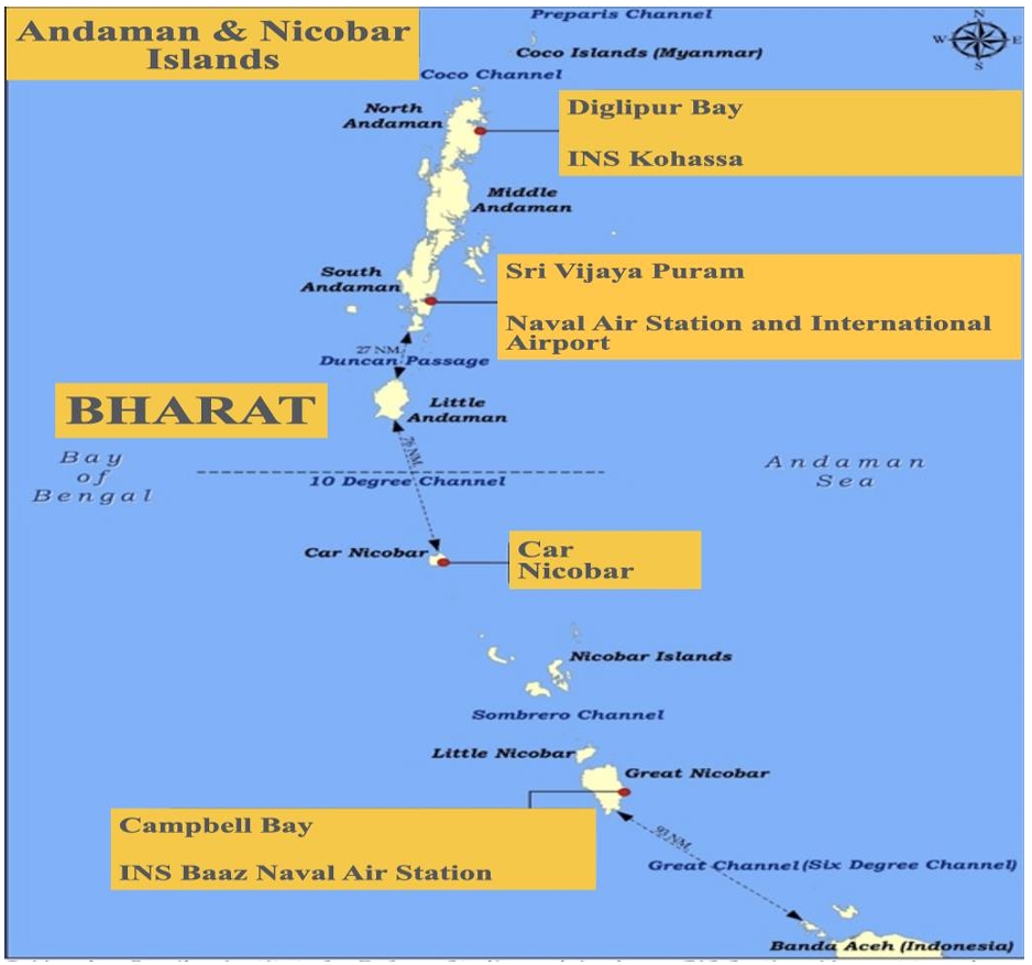
In the aviation segment, runway extension programmes at some existing airports are underway. For the northernmost airport at Diglipur/Shibpur, land allotments for the extension to a full 3-km runway are complete; works are ongoing. An extension of the southernmost runway at Campbell Bay is also under consideration, and the land acquisition process is underway. Once completed, there will be four full-length runways, each 3 km long, aligned along the islands’ north-south axis, with all airfields being dual-use.
The civil commercial flights under the UDAN (Ude Desh ka Aam Nagarik) scheme are likely to start within the next couple of months. Letters of Intent (LOIs) by the Airports Authority of India have already been issued to Skyforce, which will operate the flights. Helicopter services will also be available to tourists shortly. Seaplane trials are also ongoing for Sri Vijaya Puram, Swaraj Dweep, Shaheed Dweep, and Long Island, and, hopefully, seaplane operations for tourists will begin by the year-end. As of now, the Maldives is the biggest operator of seaplanes. We hope to become the biggest in due course.
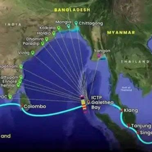
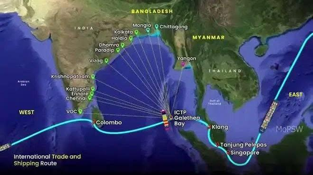
Apart from tourism, the ports and shipping segment offers the greatest potential for economic growth. To that end, we are developing an International Container Transhipment Port on Great Nicobar Island on a PPP basis. Phase I of the project will be completed within four years of the contract award and will have a capacity of just under 6 million TEUs. The final phase will have a capacity of close to 21 million TEUs. Given its geographical advantage, dominating the Strait of Malacca at the gateway to the Indo-Pacific, we believe it has the potential to become one of the most significant container-handling ports in the entire Indo-Pacific. Much, however, will depend on how efficiently the port is run.
Up north, a jetty in Atlanta Bay is being developed as a deep-water multipurpose port. A feasibility study by IIT Chennai has determined that, without dredging or the need for breakwaters—because of the natural configuration of the port—a minimum of 4 km of jetty space can be constructed in 20-30 m waters. Other experts have opined that the natural harbour has up to 10 km of jetty space. This is being handled currently on our behalf by the Syama Prasad Mookerjee Port (SPMK), Kolkata, as designated by the Ministry of Shipping. This too is rapidly moving forward.
At Port Meadows, the country’s first ship-to-ship transport terminal, north of Sri Vijaya Puram, we have already entered into a JV with Matsya, an Indo-German consortium, to develop it. This will be a net revenue model, as we will receive worldwide lease rentals from it. We expect shipping traffic around the A&N islands to increase significantly over the next five years. We have therefore entered into a 30-year MoU with Cochin Shipyard Limited (CSL) to upskill our shipyard’s HR and upgrade our infrastructure, including dry docks, handling facilities, cranes, and jetties. Through these measures, we will position ourselves as a ship repair hub, initially in the Bay of Bengal and, going forward, in the Indo-Pacific. Repair facilities in the Bay of Bengal rim countries are presently extremely rudimentary. There is thus immense potential to position ourselves not only as a ship repair hub but also as a ship construction hub.
In the power sector, we are moving towards solar power. In 2015, 90% of our generation came from diesel generators, 5% from hydroelectric power, and 5% from solar. Today, the solar component is around 25%, and over the next five years it will exceed 70%. About 20% will be generated by LNG, for which a 50 megawatt LNG power plant at Sri Vijaya Puram is coming up shortly. About 5% will remain DG for emergency use. So we are going totally renewable. We have also put forward proposals for small modular nuclear reactors, and we are hopeful that, perhaps in two locations, there will be a component of small modular reactors. Another project under consideration is a high-voltage DC cable link to the mainland, as part of our quest for clean, entirely renewable energy.
Our first five-star hotel opened only in 2020. Now, we have awarded four major hospitality contracts: two to the Radisson Group and two to the Thai global chain Anantara. All of them are clean revenue models for the administration, whose only expenditure is the provision of basic infrastructure, such as road connectivity, network, water, and power. The remaining expenditure will be incurred by the hospitality chain under the DBFOT concept (design, build, finance, operate, and at the end of the lease period, transfer it back to the administration), or through re bidding. In the coming weeks, 11 such major contracts are ready to be offloaded. So, the tourism infrastructure, which has been a major bottleneck so far, is set for a complete revamp to realise its full potential. This will include niche areas such as scuba diving, to make the Andamans a global scuba diving hub.
An internationally acknowledged professional diver, the Frenchman Jacques Cousteau, who, in the 90s, when he came to the Andamans, made a film, Andamans: The Invisible Islands, said he had dived all over the world, but the most diver-friendly and beautiful underwater habitat he found was in the waters of the Andaman Islands. This view has also been echoed by the global Professional Association of Diving Instructors (PADI).
Birdwatching is another niche area where we are developing infrastructure, guides, and facilities, as the islands are home to several bird species found nowhere else in the world. The third is astrotourism. With clear skies, zero pollution, and a location close to the equator, this is another niche area under development.
I will now cover two points that, at this stage, are still works in progress but, depending on how they unfold, could provide an overlay on the entire discourse I have covered so far. The first is the Thailand Land Bridge project. Recently, at the highest political levels in Thailand, it was announced that the project has been finalised. It is no longer a canal project but a land bridge over the same stretch where the canal was previously contemplated. This 45 km stretch will have a multi-purpose port at the Andaman Sea end in Ranong and at the Gulf of Thailand end in Chumphon. It will have multiple rail tracks for rapid transhipment of containers between sides, along with multi-lane road connectivity. It will also have pipelines for oil, petroleum, and natural gas.
This project is slated for rapid execution on a 100% PPP basis, and the bid is open to all. From the eastern end of the Chumphon port, the South China Sea is just 300 km away. In other words, the South China Sea is within 400 km of our doorstep. A significant share of traffic currently transiting the Strait of Malacca would now perhaps take this route, saving about 1,000 km each way, or about 3 days of travel time. The entire maritime scenario across the Indo-Pacific divide is set to change fundamentally. This traffic, moving along the 10th parallel and passing between the Andaman and Nicobar Islands, is of great strategic relevance to India. We dominate both the 6-degree and the 10-degree channels.
Turning to the second point, despite having one-third of the country’s EEZ and one-fourth of its coastline, no offshore oil exploration had taken place until 2020, because the entire stretch of waters around the Andaman & Nicobar group of islands was designated a “no-go zone” for oil exploration. This was due to concerns that debris from DRDO missile launches from Wheeler Island and ISRO missile launches from Sriharikota might fall in that area. Now, with technologies available to prevent that from happening, vast stretches of the ocean have been freed up for oil exploration. In 2025, Oil India Limited (OIL) found gas samples with 87% methane in Sri Vijaya Puram 2. On 27 January, ONGC “spudded” a stratigraphic well, Sri Vijaya Puram 3, which yielded crude condensate. As exploratory work proceeds, there are expectations that future finds may exceed the Guyana basin find, potentially taking India to a $20 trillion economy.
On the ground, the Offshore Areas Licensing Policy (OALP) 10 and 11 auction of offshore lots, initially planned for February, was deferred to May and has now been deferred to 19th of June. The largest-ever auction of oil blocks is taking place between these two auctions, with a significant portion of the blocks in the Andaman Basin. Our oil majors, namely Oil India and ONGC, are in advanced discussions with BP (formerly British Petroleum), ExxonMobil, Shell, and Petrobras of Brazil, which has experience in the Guyana Basin. Some JVs and MoUs already exist. These JVs and MoUs will bring not only funding but also deep-sea oil exploration technologies and, most importantly, drilling rigs specifically designed for ultra-deep-sea exploration. Ultra-deep-sea drilling technology operates at depths exceeding 1,500 m. With that, I hope what I have spoken about provides a suitable backdrop for the three sessions you have planned for the afternoon, which I think will play a pivotal role in bringing some of the mainstream thinking to centre stage, an area that has remained neglected so far.
SESSION 1
Sustainable Development, Community Governance, and Ecological Resilience in the Andaman and Nicobar Islands

For decades, discussions about the development of the Andaman and Nicobar Islands have been marked by a persistent dilemma. It was often argued that significant development would harm the islands’ fragile ecology and disrupt the unique communities that inhabit them. As a result, development and conservation were frequently seen as competing objectives rather than complementary goals. Before we begin our discussion, it is important to appreciate the sheer scale and significance of the Andaman and Nicobar Islands—something that is often not fully understood on the Indian mainland.
The Hon’ble Lieutenant Governor, Admiral DK Joshi, and Dr Ram Madhav have already highlighted some important figures, but they bear repeating. The Andaman and Nicobar Islands are larger in area than 33 sovereign states worldwide. They are nearly eleven times the size of Singapore, four times the size of Luxembourg, and larger than countries such as Brunei. Even Great Nicobar Island, which lies at the southern extremity of the archipelago and is smaller than islands such as South Andaman, Middle Andaman, and North Andaman, is about 1.25 times the size of Singapore. Remarkably, Great Nicobar alone is larger than 24 sovereign states worldwide.
These comparisons are important because they provide perspective. When concerns are raised about developmental projects, it is essential to understand that we are often discussing activities confined to relatively small areas within a much larger geographical space. At the same time, the ecological significance of these islands cannot be overstated.
The Andaman and Nicobar Islands are among India’s richest biodiversity hotspots. They are home to approximately 2,200 plant species, of which nearly 1,300 are endemic—found nowhere else in India. Similarly, of the roughly 8,300 recorded faunal species, over 1,100 are unique to these islands. For example, the islands support about 55 mammal species, 32 of which are endemic. They are also home to around 270 bird species, including nearly 90 found nowhere else in the world. These figures underscore why ecological conservation must remain central to any development strategy.
Yet development is equally important. Recent exploratory findings indicate significant hydrocarbon potential in the region. While the commercial viability and precise extent of these reserves will require further assessment, the potential is undoubtedly substantial. Coupled with the islands’ strategic location astride major maritime trade routes, this presents new opportunities for economic growth and national development.
The human dimension is equally significant. The islands are home not only to tribal communities such as the Nicobarese but also to some of the world’s last surviving aboriginal groups—the Great Andamanese, the Onges, the Jarawas, and the Shompens. These communities embody unique cultural traditions and ways of life that have endured for centuries. The Sentinelese, in particular, remain the world’s most isolated human community, maintaining virtually no contact with the outside world. Consequently, discussions of development cannot be limited to economics and infrastructure alone. They must also address questions of community governance, cultural preservation, social inclusion, and the protection of vulnerable indigenous populations.
The challenge before us, therefore, is not whether development should take place, but how it can be pursued in an environmentally responsible, socially sensitive, and economically sustainable manner. With more than 8,000 square kilometres of territory, abundant natural resources, extraordinary biodiversity, and immense strategic significance, the Andaman and Nicobar Islands possess enormous potential. The task for policymakers is to harness that potential while preserving the ecological and cultural heritage that makes these islands so unique.

It’s a privilege to be invited by the India Foundation to address this distinguished gathering on a subject that is not merely academic but of profound strategic consequence for our nation and the broader Indo-Pacific. My experience as Lieutenant Governor of the Andaman and Nicobar Islands has transformed my understanding of what it means to govern a territory where geography, ecology, security, and civilisational legacy converge in ways unlike anywhere else in the Indian Union. The Andaman and Nicobar Islands are not a footnote in India’s story. In many ways, they are a window into India’s future—a future shaped by its maritime identity, its Indo-Pacific engagement, and its emergence as a leading power in the Indian Ocean region.
Geography, as we know, often shapes destiny. The Andaman and Nicobar archipelago comprises 836 islands, islets, and rocks, of which only a small fraction are inhabited. It stretches nearly 800 kilometres from north to south, astride the 10-degree channel, through which approximately one-third of global maritime trade passes each year. The eastern mouth of the Strait of Malacca, perhaps the single most important choke point in international shipping, lies within reach of our southernmost tip. This is not a strategic asset we inherited by accident; it’s a gift of geography that demands a response commensurate with that vision.
For much of independent India’s history, the islands have been viewed either through the lens of the Cellular Jail and our freedom struggle, or as a repository of unique biodiversity requiring protection. Both perspectives are important. Yet the demands of the twenty-first century require us to see the islands in their entirety—as a strategic frontier, an ecological treasure, a developmental opportunity, and a national responsibility. During my tenure as Lieutenant Governor, I was repeatedly struck by the difficulty of balancing these imperatives. The task for policymakers is not to choose between them but to harmonise them. That, in my view, remains the central challenge of governance in the Andaman and Nicobar Islands.
Let me first turn to security, for without it neither ecology nor development can flourish. The geographical and geopolitical environment in the Indo-Pacific has changed dramatically over the past decade. The rise of China as a blue-water naval power, the militarisation of the South China Sea, the growing frequency of extra-regional naval presence in the Indian Ocean, and the intensification of competition among major powers for maritime influence—all of these trends converge on the Andaman and Nicobar Islands with particular force.
India’s Andaman and Nicobar Command, established in 2001 as our first and only tri-service theatre command, was a prescient institutional response to these emerging realities. It remains, to this day, a model of joint military thinking that the rest of our defence establishment continues to aspire to. During my tenure, I had the opportunity to work closely with successive commanders and to see firsthand the professionalism and dedication of our armed forces personnel stationed in conditions of considerable remoteness and hardship. However, the gap between the strategic importance of these islands and the resources allocated to their defence infrastructure has been a persistent concern. Our runways, port facilities, surveillance capabilities, and logistics chains have all required sustained investment over many years.
The Government of India is now showing a heightened appreciation of this imperative. The holistic development of the Great Nicobar Island project, the upgrading of Andaman and Nicobar Command’s capabilities, and the broader push for maritime domain awareness mark a welcome acceleration of national intent. Yet I would urge even greater urgency. The window of strategic advantage is not permanent. Our geographical position in the eastern Indian Ocean will realise its full deterrent and shaping potential only if it is underpinned by credible military capability, modern infrastructure, and effective domain awareness. I would also emphasise the importance of deepening our engagements with like-minded partners in the Indo-Pacific: the United States, Japan, Australia, France, and others, through the lens of the Andaman and Nicobar Islands. These partnerships can be structured to enhance our sovereignty and strategic autonomy rather than dilute them, provided we approach them with clarity of purpose and confidence in our own vision.
Let me now speak about ecology. The Andaman and Nicobar Islands contain some of theplanet’s most biologically diverse ecosystems. They are home to over 2,200 plant species, nearly 350 bird species, and an extraordinary array of marine life. The coral reefs of the Andaman Sea are among the richest and most resilient in the Indo-Pacific. The Nicobar group, in particular, harbours species such as the Nicobar megapode and the crab-eating macaque, which are found nowhere else on Earth. Several of our tribal communities, including the Jarawas, Sentinelese, and the Onges, have lived in these ecosystems for tens of thousands of years, representing an irreplaceable continuity of human adaptation to the natural world. The 2004 tsunami was a brutal reminder that the natural systems of these islands, including mangroves, coral reefs, and coastal vegetation, serve as the first line of defence for human settlements. Where these systems were intact, communities survived. Where they had been degraded, the destruction was catastrophic. I am therefore strongly supportive of a calibrated, evidence-based approach to development that places ecological carrying capacity at the centre of planning.
The paradox of the Andaman and Nicobar Islands is that they lie at the crossroads of global commerce, yet their residents have long been economically marginalised by their distance from mainland markets and the administrative complexities of Union Territory governance. I am particularly convinced of the transformative potential of sustainable tourism in the Andaman Islands. The natural beauty of these islands, with their pristine beaches, crystal-clear waters, and rich marine life, is without parallel in the Indian subcontinent. A well-regulated, high-value tourism sector, developed with strict environmental safeguards and strong community participation, could generate substantial livelihoods while building a constituency for conservation among local residents. I would strongly advocate adopting a blue economy framework that treats the islands’ marine resources not merely as commodities to be extracted, but as assets to be sustainably managed for the long-term benefit of island communities.
Equally important is the question of connectivity. The undersea optical fibre cable now linking the islands to the mainland is a significant achievement, bringing broadband to communities previously reliant on satellite links with limited bandwidth. This infrastructure can be leveraged to create new opportunities in digital services, telemedicine, and distance education. However, physical connectivity, through improved air links and inter-island ferry services, remains a critical, unfinished agenda.
No discussion of governance in the Andaman and Nicobar Islands can be complete without reference to the extraordinary responsibility we bear towards the indigenous tribal communities of these islands. The Andaman people, the Jarawas, the Sentinelese, the Great Andamanese, the Onges, and others are among the most ancient human communities on Earth. Their genetic lineages trace directly to the earliest migration of Homo sapiens out of Africa. They are, in a very literal sense, living links to the deepest chapters of the human story. Our constitutional and moral obligation to these communities is absolute. The policy of protecting their habitat from external contact, imperfect in its implementation though it has sometimes been, rests on the hard-earned wisdom that these communities are extraordinarily vulnerable to the diseases, social disruptions, and cultural dislocations that external contact brings. The Andaman Trunk Road, which passes through the Jarawa Reserve, remains a source of justified concern from a protection standpoint, and I would urge continued attention to this question from both the administration and civil society. At the same time, we must guard against paternalism that denies these communities any agency in shaping their own futures. The principle must be respect for their autonomy and choices, informed by the best available anthropological and epidemiological knowledge and guided by a genuine commitment to their well-being rather than by any external agenda, whether development- or culture-related.
No single initiative more powerfully crystallises India’s 21st-century vision for the Andaman and Nicobar Islands than the holistic development of Great Nicobar Island. Situated at the southern extremity of our archipelago, barely 90 nautical miles from Sumatra and overlooking one of the world’s busiest maritime corridors, Great Nicobar holds exceptional strategic importance. For decades, India had this advantage but lacked the infrastructure to realise its full potential. The Great Nicobar project seeks to bridge that gap.
The proposed transhipment port, international airport, supporting township, and dual-use strategic infrastructure are far more than a development project. They constitute a long-term investment in India’s maritime future, economic competitiveness, and strategic reach in the eastern Indian Ocean. The significance of the transhipment terminal alone cannot be overstated. For too long, Indian trade has relied on foreign ports for transhipment. Great Nicobar offers the opportunity to retain a larger share of that economic value within India while establishing a major maritime hub at one of the world’s most important trading crossroads.
Equally significant is the strategic dimension. A strengthened Indian presence on Great Nicobar will enhance maritime domain awareness, strengthen deterrence, and reinforce India’s ability to contribute to stability and security across the wider Indo-Pacific. Naturally, concerns about ecology and indigenous communities must be taken seriously. They deserve rigorous assessment, continuous monitoring, and responsible mitigation. But environmental stewardship and strategic development need not be seen as opposing objectives. The challenge is to pursue both with wisdom, sensitivity, and foresight. What we must avoid is allowing caution to become paralysis. Strategic opportunities do not remain available indefinitely. Infrastructure of this scale requires years of planning and execution, and the costs of inaction can be as high as the risks of action.
Great Nicobar is therefore more than an island. It is a statement of India’s intent—a recognition that our maritime geography is among our greatest national strengths and that we have both the confidence and the vision to harness it responsibly.

By way of introduction, I had the privilege of serving as Deputy Commissioner of Car Nicobar in the Nicobar Islands for two years. During that period, I travelled extensively across the Nicobar group and visited virtually every inhabited island, including the lighthouse at Indira Point, which was submerged after the 2004 tsunami. My association with the islands extends beyond administration. I was also involved in establishing the first scuba diving society in the Andaman and Nicobar Islands, which gave me a unique perspective on the region’s extraordinary maritime and ecological wealth.
The Andaman and Nicobar Islands pose a fascinating and complex challenge, where ecological preservation, economic development, and national security imperatives intersect. Balancing these often competing priorities requires a nuanced, integrated approach to governance and policymaking. My interest in these issues led me to write a book nearly a decade ago for the Institute for Defence Studies and Analyses, titled The Andaman and Nicobar Islands: India’s Untapped Strategic Assets. The central argument of that work was that these islands possess immense strategic potential, which, if developed thoughtfully and sustainably, could significantly enhance India’s maritime and geopolitical position.
The Strait of Malacca is one of the world’s most critical maritime chokepoints and a strategic asset of immense significance. In 2003, Chinese President Hu Jintao famously referred to the “Malacca Dilemma,” highlighting China’s vulnerability arising from its dependence on this narrow sea lane for energy supplies and trade. For India, however, the Strait represents a significant strategic advantage—provided we can fully leverage the geographic potential of the Andaman and Nicobar Islands, which lie astride the Strait’s western approaches. The importance of these islands is further underscored by the fact that nearly one-third of India’s Exclusive Economic Zone (EEZ) is associated with the Andaman and Nicobar archipelago. As maritime competition intensifies and the Indo-Pacific assumes greater geopolitical significance, this vast maritime domain and the islands’ strategic location are becoming increasingly important to India’s security, economic interests, and regional influence.
In the Andaman and Nicobar Islands, indigenous populations experience vastly different realities of survival, autonomy, and integration into modernity. At one end of the spectrum are the Nicobarese, who have successfully integrated into mainstream society. While they face modern socio-economic challenges, such as addressing unemployment among their increasingly educated youth, they are also celebrated for their vibrant culture and athletic prowess, having won the prestigious Subroto Mukerjee Football Tournament multiple times. The Shompen of Great Nicobar, a vulnerable group of roughly 200 to 300 individuals, require careful, non intrusive welfare and conservation support. The Jarawas live within a designated reserve bisected by National Highway 4 (NH4). The Onge tribe has been deeply affected by direct state intervention. The government’s initiative to resettle them into permanent housing remains highly controversial; critics argue that these forced modernisations have disrupted their traditional way of life and fostered systemic dependency rather than genuine empowerment. The islands’ most isolated populations, the Sentinelese, continue to live in absolute seclusion on North Sentinel Island. It was here that an American missionary was killed by a Sentinelese arrow. The Great Andamanese population has dwindled to just a few dozen survivors.
On the strategic side, various issues keep emerging. Many years ago, the Indian Navy sought to establish a radar station on Narcondam Island, a remote, uninhabited volcanic island in the Andaman Sea. At just 6.8 square kilometres, it juts towards Thailand and is India’s easternmost island, famed as the exclusive, protected home of the endangered Narcondam Hornbill. The government denied permission to set up the radar station on the grounds that it would endanger the 300 or so hornbills endemic to the island. Here, environmentalists overrode strategic requirements, despite there being no evidence that a radar station posed a threat to the hornbills.
Another issue has arisen with the Great Nicobar Island project at Galathea Bay. Currently, the controversies surrounding the project concern the Shompen tribe and the turtles’ nesting sites. Indira Point, south of the island, is now underwater after the 2004 tsunami, but the lighthouse there, though partially submerged, still functions. With the transhipment port, an increase in ships will cause some water pollution, as we have seen in Singapore. Also, the structures being built must be designed to withstand earthquakes of magnitude 8 or 9 on the Richter scale. This needs to be ensured.
The Ten Degree Channel, which separates the Andaman and Nicobar groups of islands, warrants particular attention. India argued that the channel should be treated as internal waters, thereby giving it greater control over transit by foreign vessels. However, this position was not accepted under the United Nations Convention on the Law of the Sea (UNCLOS). By contrast, countries such as Indonesia, as archipelagic states, enjoy greater rights over waters enclosed by their archipelagic baselines. This distinction has important strategic implications. The Ten Degree Channel is a critical maritime passage, and there are growing concerns about its use by foreign naval vessels, including Chinese submarines transiting between the Bay of Bengal and the wider Indo-Pacific. Given the changing security environment in the region and the growing strategic importance of the Andaman and Nicobar Islands, it may be worthwhile for India to revisit the legal and diplomatic aspects of this issue and explore whether a stronger case can be made for enhanced regulatory control over this vital waterway.
An international airport is planned for Great Nicobar Island. However, it may be worthwhile to assess whether existing infrastructure can be used more effectively before embarking on an entirely new facility. The islands already host INS Baaz at Campbell Bay, a strategically located naval air station under the tri-service Andaman and Nicobar Command. Subject to operational and technical feasibility, extending its runway and expanding associated facilities could meet both strategic and civilian aviation requirements at lower environmental and financial costs. Alternative engineering solutions could also be explored. Several countries, most notably Japan, have successfully developed airport infrastructure through land reclamation and offshore extensions, thereby minimising the impact on ecologically sensitive terrestrial areas. Given the unique environmental significance of Great Nicobar, such options merit careful consideration as part of a broader assessment of developmental needs, strategic imperatives, economic viability, and ecological sustainability.
Another aspect that merits consideration is the natural deep-water harbour at Nancowry, located between the islands of Nancowry and Kamorta in the Central Nicobar group. This harbour, utilised by the Japanese during the Second World War, offers significant natural advantages as a sheltered anchorage. Its geography is particularly noteworthy, with navigable access channels providing entry and exit routes, making it a strategically valuable maritime asset. The Indian Navy already maintains a presence here through INS Kardip, a Forward Operating Base on Kamorta Island that operates under the tri-service Andaman and Nicobar Command. Commissioned in 1973, the base contributes to India’s maritime surveillance and operational capabilities in this strategically important region. The presence of such infrastructure raises broader questions about the optimal utilisation of resources across the island chain. For example, both civilian authorities and the Navy maintain adjacent helipads in the area. While there may be valid operational reasons for separate facilities, it is worth examining whether greater integration and shared-use arrangements could enhance efficiency, reduce duplication, and minimise the environmental footprint of future development.
In conclusion, the Andaman and Nicobar Islands would benefit from a comprehensive assessment of existing assets before undertaking new infrastructure projects, ensuring that strategic, economic, and ecological considerations are addressed in a balanced and coordinated manner.

Major infrastructure projects in India have long been the subject of vigorous public debate, which is both healthy and necessary in a democracy. I recall the discussions surrounding the Enron power project, the country’s first large-scale private-sector power venture. At the time, I had reservations about the high cost of the electricity it would produce. Yet I also felt the project could serve as a catalyst for broader change—encouraging Indian entrepreneurs to enter the power sector and fostering a culture in which consumers and state utilities recognised the need to pay the true cost of electricity. The underlying logic was sound, even if the outcome ultimately fell far short of expectations. That experience has made me cautious about assuming that every grand plan will unfold exactly as envisioned. At the same time, uncertainty cannot be a reason for inaction. If we allow fear of failure to prevent us from undertaking ambitious projects, we risk condemning ourselves to stagnation.
Change has brought us many benefits, and they are now visible: you can see them in every National Family Health Survey, and you will also see them when the census report comes out. You’re already seeing it in the population figures; a country that once had such massive panic and fear about the population bomb is now, in my lifetime, worrying about having too few babies. So things can change dramatically; not all fears come true. And that’s how fears have to be seen, rationally, not embraced instinctively. And some of that is happening in the Andaman Nicobar area as well.
On the issue of developments in Great Nicobar, environmentalists want to preserve the pristine environment as it is. The political argument by opposition groups against this development is that if it were such a good idea, they would have implemented it when they were in power for six or seven decades! The fact is that everything changes. On Hainan Island, the Chinese, while creating provisions for military facilities, have preserved their forests.
The Andaman and Nicobar Islands and Lakshadweep are two fantastic geopolitical, ecological, and economic opportunities for India. By not developing them, we have allowed them to become security liabilities, as India has to invest heavily in their protection. Leaving them as they are risks becoming like the absentee landlord who goes overseas and, on his return, finds that somebody has occupied his land. During the 1965 war, Sukarno talked about annexing the Andaman and Nicobar Islands. In Air Marshal Asghar Khan’s autobiography, there are conversations between him and the then Indonesian Navy Chief, who said, “What business does India have to own these islands? These fall between East Pakistan and the Sumatra region of Indonesia, and belong to us. We will just go and take them; India has no navy anyway.”
When Sukarno fell, things changed. However, when the Indian Navy inducted the Tu-142Ms, long-range maritime reconnaissance and anti-submarine warfare aircraft, Admiral Hartas, an Indonesian admiral, stated that it was now time to act on these islands because Indonesia had a stronger claim to them than India, particularly to the Nicobar Islands. That is why it is necessary to convert a security liability into a security asset. While we do not need to militarise the Islands, we need to use geography to our advantage should the need arise, as Iran has shown in its conflict with the United States. We are not building an asset to block the Strait of Malacca. That, in any case, is a bad and very provocative idea, as it will affect many of India’s friends and India’s trade.
A cursory look at the map of India shows that India’s economic growth is weighted towards its western seaboard, which hosts major commercial centres, modern ports and airports. The Eastern seaboard is comparatively less developed. While the Indian Navy has some of its most valuable assets on the Eastern coast, such as INS Varsha, where the nuclear submarines are based, the rest of India’s Eastern seaboard is quite bare. If the Kra Canal is built in Thailand, or even if a highway project connecting one side to the other is constructed, it would immediately open up all of India’s Eastern coast to the rest of the world. India has defence assets on its Eastern seaboard, but a military presence in the A&N islands overlooking the region would pay great dividends and provide India with defence in depth.
The Chinese already have Hambantota, and in Coco Island, which is not far from the Andamans, they have an airstrip longer than INS Baaz. There is nothing more important than a nation’s defence. We need to be prepared to fight the wars of tomorrow, and not those of yesteryears. But more importantly, we need to avoid wars through deterrence, and raise the costs of any misadventure for an aggressor.
As for the transhipment port in Galathea Bay, the environmental concerns have been addressed as far as possible. It is also surprising to see many naval veterans on social media saying the port will not be commercially viable. How they have reached that conclusion is unclear, but in any case they know little about commerce. That aspect will be handled by private companies, and no private company will sink its shareholders’ money into an infeasible project.
What we need is more communication and more debates like this. We need to move beyond the old Planning Commission mindset, in which the pre-reform question was: “Will India need this or not?” One of the Planning Commissions in the late 1980s said that India should not issue licences to produce additional cars because the Indian market could not absorb more than 50,000 cars. Today, India manufactures 5–6 million cars and exports a large number as well.
The time has come for India to think big, without being reckless. For understandable reasons, our strategic outlook has traditionally been shaped by continental concerns. Most of the threats we have faced since Independence have emanated from our land borders, making us largely border-centric in our strategic thinking. Today, however, we need to broaden our strategic horizon and look beyond our frontiers. Future challenges may not necessarily take the form of an adversary seeking to capture another square kilometre in Ladakh or another ridge line near Tawang. Such ventures are increasingly costly, both politically and militarily. The maritime domain presents a very different set of challenges.
In this context, I am reminded of remarks reportedly made by Pakistan Army Chief Field Marshal Asim Munir during a speech in Tampa, Florida. Referring to a future conflict, he reportedly said, “The next time, we will start from the East,” adding, “Isn’t it there, on the Eastern side, that they keep what is most valuable to them?” Many interpreted this as a reference to the Siliguri Corridor or to developments involving Bangladesh. My own reading was somewhat different. I believe he was drawing attention to India’s eastern maritime seaboard and the vulnerabilities that could arise in the maritime domain.
Whether that interpretation is correct or not, the broader point remains valid. Future threats are likely to be more complex, technologically enabled, and less predictable than those we have traditionally planned for. Advances in unmanned systems mean that powerful drones and autonomous platforms can be deployed from commercial vessels, fishing boats, shadow tankers, or dark fleets operating far from conventional battlefields. The distinction between civilian and military activity at sea is becoming increasingly blurred.
India must therefore prepare for the future rather than remain anchored in the assumptions of the past. Geography has bestowed unique maritime advantages on us, particularly in the Andaman and Nicobar Islands. The challenge before us is to develop and leverage these assets responsibly, balancing environmental considerations with economic and security imperatives. Seen in that light, the Great Nicobar project is not merely a development initiative; it is part of a broader effort to position India for the strategic realities of the twenty-first century.
SESSION 2
Andaman and Nicobar Islands as a Focal Point for Maritime Security andRegional Cooperation in the Indo-Pacific

The Andaman and Nicobar Islands, located 1,200 kilometres or more off the coast of India, serve as India’s premier maritime outpost, anchoring its security strategy and regional cooperation in the Indo-Pacific region. The archipelago overlooks one of the world’s busiest sea lines of communication, with 90,000 ships a year passing through it—30 per cent of all global trade, according to the World Economic Forum, including two-thirds of China’s global trade, 80 per cent of China’s energy imports, 45 per cent of all seaborne oil transit in the world, and 55 per cent of India’s merchandise trade.
As we see in real time, the importance of maritime choke points cannot be overstated. Great Nicobar Island is a natural choke point, vital for monitoring shipping traffic and countering conventional and unconventional threats, including piracy, illegal fishing, and maritime terrorism. The establishment of the Andaman and Nicobar Command, India’s only operational tri-services command, in 2001 underscores the strategic value of the islands. A robust presence on Great Nicobar enables India to project power, monitor threats, and provide rapid humanitarian assistance and disaster relief across the Bay of Bengal and the Western Pacific.
Beyond defence, the islands are a launchpad for regional diplomacy under the Act East policy. India has begun to leverage this geography to deepen ties with Southeast Asian nations, including Thailand, Indonesia, Malaysia, and Myanmar, which lie between 100 and 400 nautical miles from the islands. The islands host multinational naval exercises, such as the Milan exercises and coordinated patrols, or CORPATs, with navies from these countries. By expanding infrastructure and promoting sustainable economic corridors, India has transformed the archipelago from an isolated frontier into a vibrant hub for collaborative ocean governance, ensuring a free, open, and inclusive Indo-Pacific.

It’s a privilege to speak about a region that has moved from the margins of India’s strategic thinking to the centre of the Indo-Pacific geopolitical maritime arena. I’ll speak from my experience as CINCAN, an Air Force officer in a maritime environment, from 2012 to 2014.
It is important to recognise that the strategic value of these islands begins with geography. Stretching nearly 750 kilometres north-south at the mouth of the Malacca Strait, they occupy one of the most strategic positions in the Indo-Pacific region. Their proximity to the Strait of Malacca, through which almost one-third of global trade and much of the energy supplies for East Asian countries pass, gives them exceptional strategic value.
They provide a vantage point over the Sunda and Lombok Straits, strengthening India’s ability to monitor critical maritime gateways between the Indian and Pacific Oceans. In an era when disruptions at chokepoints such as the Suez Canal, the Red Sea, the Strait of Hormuz, and the Strait of Malacca can reshape global trade and security, geography has once again become a strategic determinant of power. Few locations in the Indo-Pacific offer India a comparable strategic advantage. This century has seen India’s transition from a predominantly continental orientation to a balanced continental-maritime one.
This evolution is evident in India’s transition from the Look East policy to the more proactive Act East approach; the articulation of SAGAR and its subsequent expansion into MAHASAGAR; the consistent emphasis on a free, open, and inclusive Indo-Pacific across regional and global forums; and India’s growing engagement with regional institutions. Our aspiration to become a net security provider in the region is integral to this strategic transformation. In this broader vision, the Andaman and Nicobar Islands have emerged as an indispensable strategic asset, central to advancing India’s maritime interests and broader regional objectives.
A major milestone in the strategic evolution of these islands came in 2001 with the establishment of the Andaman and Nicobar Command (ANC), India’s first and only integrated tri-service command. By bringing together the Navy, Army, Air Force, and Coast Guard under a unified operational structure, the ANC marked a significant step towards jointness and integrated warfighting. What began as a naval command headquartered in these islands was transformed into a truly joint command, reflecting a forward-looking approach to national security. Over the past two decades, the ANC has evolved from a relatively remote military formation into a key operational hub for India’s Act East policy and a critical pillar of our Indo-Pacific strategy. Its importance today extends far beyond territorial defence; it serves as a platform for maritime domain awareness, power projection, humanitarian assistance and disaster relief, and engagement with regional partners.
The command structure was carefully designed to address concerns about inter-service integration. At its apex is the Commander-in-Chief, Andaman and Nicobar Command (CINCAN), supported by component commanders from the Army, Navy, and Air Force, each responsible for overseeing their respective service elements and providing professional military advice. This arrangement addressed initial apprehensions about officers from one service commanding personnel from another, while preserving service expertise within a genuinely integrated framework. The ANC thus became an important precursor to the joint theatre command structures that India is now seeking to develop.
In the ANC’s early years, the idea of an integrated tri-service command met with hesitation. Individual Services had understandable reservations, rooted in both institutional mindsets and genuine resource constraints. At the time, the Services were grappling with shortages on the mainland and were cautious about allocating scarce assets to a distant island territory. Over time, however, experience demonstrated the value of jointness, and these initial concerns gradually diminished.
A decisive shift has occurred in recent years. There has been a marked increase in attention to the islands, reflected in substantial infrastructure investment and the steady deployment of military assets. While resource constraints persist, every effort is being made to strengthen the islands’ operational capabilities and integrate them more closely into India’s broader strategic framework.
The development of key military installations illustrates this transformation. The expansion of INS Baaz at Campbell Bay has significantly enhanced India’s ability to monitor and operate in the eastern approaches to the Indian Ocean. While discussions continue over the relative merits of various infrastructure projects on the islands, it is important to recognise that INS Baaz faces geographical and developmental constraints that limit further expansion. Similar efforts are underway at INS Kohassa in the northern islands. The runway at Car Nicobar, which was extensively damaged in the 2004 tsunami, has been rebuilt and restored to full operational capability. In addition, substantial investments have been made in naval and Coast Guard infrastructure, as well as in the deployment of advanced platforms and equipment.
These assets are critical to strengthening maritime domain awareness, intelligence, surveillance and reconnaissance (ISR), long-range air operations, logistics support, and humanitarian assistance and disaster relief (HADR) missions. They are integral to India’s ability to respond rapidly to security contingencies and natural disasters across the region. From an Air Force perspective, the islands significantly enhance India’s ability to project presence and influence across the Indian Ocean Region and, increasingly, the wider Indo-Pacific. The Indian Air Force and Indian Navy regularly participate in exercises with regional partners, including Australia, Japan, Singapore, and several neighbouring countries. Cooperative patrols and coordinated maritime activities are now routine, reflecting a growing network of security partnerships and shared maritime interests.
The proposed Great Nicobar Project marks the next stage in India’s island strategy. The first phase has focused on developing the islands’ strategic and military infrastructure; the next phase aims to unlock their broader economic and geopolitical potential. The project could significantly enhance India’s strategic leverage in the Indo-Pacific while reinforcing the geopolitical relevance of the Strait of Malacca and the wider maritime commons.
The significance of the Andaman and Nicobar Islands, however, extends far beyond their military utility. Their proximity to Indonesia, Myanmar, and Thailand offers important opportunities for economic integration, connectivity, and diplomatic engagement. Through the SAGAR vision— Security and Growth for All in the Region—India has sought to combine security with partnership. The islands support maritime diplomacy, capacity building, information sharing, and HADR operations, and serve as an important platform for India’s wider Indo-Pacific initiatives.
The Quad adds another important dimension to this evolving architecture. Although not a formal military alliance, it seeks to promote a free, open, inclusive, and rules-based Indo-Pacific through cooperation on maritime security, critical technologies, resilient supply chains, and regional capacity building. In this context, the Andaman and Nicobar Islands provide India with a unique strategic position from which to contribute to regional initiatives while preserving its strategic autonomy.
At the same time, any balanced assessment of the islands must acknowledge the challenges involved. Increased strategic activity and infrastructure development will inevitably attract greater scrutiny from regional competitors, particularly China. This reality must be recognised and managed prudently by India. Development must therefore proceed in a way that strengthens security while encouraging cooperation wherever possible.
Equally important are concerns about environmental sustainability, tribal rights, climate vulnerability, and ecological fragility. These issues require careful stewardship and responsible governance. Infrastructure development on the islands is both costly and logistically demanding. Building and maintaining facilities more than 1,200 kilometres from the Indian mainland, across a dispersed archipelago, poses unique challenges. Connectivity, healthcare, education, and the availability of skilled manpower all require sustained, long-term investment.
The central challenge for policymakers is therefore to ensure that security imperatives and sustainable development reinforce rather than undermine one another. A careful balance among strategic requirements, economic growth, environmental protection, and social welfare will be essential to the long-term success of India’s island strategy.
In conclusion, the Andaman and Nicobar Islands reflect India’s growing recognition of the maritime domain as a central pillar of national strategy. Once viewed primarily as a remote outpost, they are now an integral part of India’s Indo-Pacific vision. As they become increasingly woven into India’s economic, diplomatic, and security architecture, the islands have emerged as instruments of both deterrence and cooperation. Situated at the crossroads of the Indian and Pacific Oceans, they serve as India’s forward maritime bastion. The task ahead is clear: to ensure their development remains secure, sustainable, and strategically relevant in the decades to come.

The Andaman and Nicobar Islands have emerged as critical geopolitical and geo-economic assets for India and its Indo-Pacific partners. As India’s easternmost territory, the archipelago serves as a natural interface between South Asia and Southeast Asia. Given China’s growing military presence in the Indian Ocean Region and the Bay of Bengal, the islands have become even more significant to India’s national security.
The military and economic development of the Andaman and Nicobar Islands, together with the enhancement of India’s power-projection capabilities, is an important component of our deterrence strategy. Events along our northern borders in recent years have reinforced the need to reassess the strategic importance of these islands. Their location astride some of the world’s most vital maritime chokepoints places them at the centre of global trade flows, including the movement of energy supplies and hydrocarbons that are critical not only to China but also to Japan, South Korea, and many other economies in the Indo-Pacific.
China’s dependence on these sea lanes has long been recognised as a strategic vulnerability. The so-called “Malacca Dilemma,” a term popularised by former Chinese President Hu Jintao, reflects Beijing’s concern about reliance on the Strait of Malacca. This concern has prompted China to explore alternative routes, including proposals for a canal across Thailand’s Kra Isthmus. Even if such projects materialise, the Andaman and Nicobar Islands’ proximity to these alternative maritime corridors will ensure that the Andaman and Nicobar Command (ANC) continues to play a crucial role in maintaining maritime security in the region.
Recent developments elsewhere have only reinforced the importance of strategic geography. Events in the Strait of Hormuz and the threats posed by the Houthis in the Bab-el-Mandeb have shown how vulnerable global trade is to disruptions at key maritime chokepoints. The world is now acutely aware of the strategic value of controlling and securing such waterways. India displayed considerable foresight when it established the Andaman and Nicobar Command in 2001, the country’s first integrated tri-service command. As Air Marshal Roy noted earlier, progress could perhaps have been faster. Nevertheless, the changing geopolitical environment has made it abundantly clear that India has no option but to strengthen the archipelago’s military and economic infrastructure. This is precisely the direction in which current policy is moving.
The islands play a vital role in regional maritime security. Their proximity to the Six Degree Channel, one of the world’s busiest shipping lanes, together with the surveillance and military assets deployed there, gives India significant strategic advantages. Over the years, the islands have become an important hub for maritime domain awareness. The archipelago hosts an extensive network of radar stations and coastal surveillance systems linked to the Information Fusion Centre–Indian Ocean Region (IFC-IOR) in Gurugram. These systems collect and transmit critical information on the movement of naval vessels, submarines, research ships, and commercial traffic across the region. The IFC-IOR, an Indian initiative with growing international participation, has become a key mechanism for information sharing and maritime cooperation.
The islands also support the monitoring of commercial shipping and contribute significantly to India’s white-shipping agreements with nearly forty countries. These arrangements facilitate the exchange of information on merchant shipping and strengthen maritime security cooperation across the Indo-Pacific. In addition, surveillance systems based in the Andaman and Nicobar Islands increasingly contribute to broader regional monitoring networks, including collaborative arrangements with like-minded partners. Through these initiatives, the islands have become a focal point for maritime cooperation and collaborative security diplomacy.
The archipelago also serves as a valuable platform for joint military exercises, coordinated patrols, anti-piracy operations, and humanitarian assistance and disaster relief (HADR) missions. India conducts SIMBEX with Singapore, bilateral exercises with Australia and other regional partners, and increasingly sophisticated naval engagements that enhance interoperability and maritime security cooperation. The Coordinated Patrol (CORPAT) mechanism with Indonesia, Thailand, and Myanmar provides another important avenue for regional cooperation. These patrols address challenges such as illegal fishing, smuggling, and other transnational maritime crimes in areas where India shares maritime boundaries with its neighbours.
India also participates in the Malabar Exercise alongside the United States, Japan, and Australia, while the MILAN series of exercises has evolved into one of the region’s largest multinational naval gatherings. Together, these initiatives have strengthened military-to-military ties, enhanced trust among partners, and reinforced India’s role as a net security provider in the Indo Pacific. Across these endeavours, the Andaman and Nicobar Islands play an indispensable role. The islands are also important to the implementation of several Quad initiatives, including the Indo-Pacific Partnership for Maritime Domain Awareness and the Quad Partnership for Cable Connectivity and Resilience. The latter reflects the growing strategic importance of undersea communication cables, which are now as vital to the global economy as maritime shipping lanes. Given their proximity to major submarine cable routes linking Asia, Africa, and Europe, the Andaman and Nicobar Islands are uniquely positioned to contribute to the security and resilience of these critical networks. As India’s former Ambassador to Japan, I would also like to emphasise the importance of the islands in the context of India-Japan relations. Japan has long recognised the strategic significance of the Andaman and Nicobar Islands. Our relationship with Japan is distinguished not only by shared strategic interests but also by a high degree of trust. This trust is evident in Japan’s involvement in infrastructure development projects in some of India’s most sensitive regions, including the Northeast.
Although no agreement is specifically dedicated to the Andaman and Nicobar Islands, several bilateral initiatives are directly relevant to the archipelago. One of the most significant is the Chennai–Andaman and Nicobar submarine optical fibre cable project, implemented by BSNL in partnership with Japan’s NEC Corporation. This project has transformed digital connectivity across the islands by dramatically increasing bandwidth and enabling improvements in governance, telemedicine, education, and disaster resilience.
Another important initiative is a grant from the Japan International Cooperation Agency (JICA) to support renewable energy and grid infrastructure on the islands. Given the archipelago’s remoteness and the need for self-sustaining energy systems, the project has been critical to strengthening energy security and ensuring a reliable power supply for both civilian and military infrastructure.
Several additional projects are under discussion across areas including port modernisation, disaster-resilient infrastructure, sustainable development, and connectivity. Japan’s expertise in these fields is widely recognised. The Smart Islands initiative, which includes the Andaman and Nicobar Islands and Lakshadweep, offers another promising avenue for collaboration. It seeks to integrate infrastructure development with environmental sustainability and resilience, ensuring that economic growth does not come at the expense of ecological balance.
As India seeks to strengthen its position in the Indo-Pacific, the Andaman and Nicobar Islands will remain central to our strategic thinking. Their significance lies not merely in their location but in their capacity to serve as platforms for security, connectivity, economic development, regional cooperation, and strategic partnerships. The challenge before us is to harness this potential sustainably and resiliently, and to align it with India’s long-term national interests.

I come to this discussion with mixed feelings. On the one hand, there is encouraging news: we are finally talking seriously about the Andaman and Nicobar Islands. Fifteen years ago, when I was associated with institutions such as the Institute for Defence Studies and Analyses (IDSA), the Centre for Policy Research (CPR), and later Carnegie India, we repeatedly sought to raise awareness of the islands’ strategic significance. There was little enthusiasm. Beyond some interest from Japanese foundations and scholars, the subject scarcely featured in policy discussions in New Delhi. Only during the present government’s second term did we begin to see a more sustained focus on the islands, marked by the commissioning of major studies and followed by a series of policy initiatives. That is undoubtedly welcome.
Yet this positive development raises a more uncomfortable question: why did it take nearly eight decades after Independence for India to recognise the strategic value of an asset whose importance is, to any student of geopolitics or maritime strategy, self-evident? The growing attention the islands are receiving today is partly a consequence of current debates over development projects in the archipelago. My hope is that this renewed interest is not merely a passing phase but the beginning of a sustained national effort to integrate the islands into India’s long-term strategic vision. I would like to make three broad points. The first two concern the past; the third looks to the future.
The first concerns what I regard as a significant weakness in India’s strategic culture: the absence of a strong territorial sensibility in the maritime domain. This may seem surprising. Independent India has always been deeply conscious of territorial issues. We have been preoccupied with borders, territorial disputes, and questions of sovereignty. Yet this awareness was overwhelmingly continental in orientation. When it came to maritime spaces and island territories, there was a striking lack of strategic attention.
The history of the Andaman and Nicobar Islands during Partition illustrates this point. Given the complex political circumstances surrounding the subcontinent’s division, several outcomes were conceivable. The islands might not have become part of India. That they did owes as much to historical contingencies as to deliberate strategic planning. At a time when New Delhi was understandably preoccupied with Partition, Kashmir, and later China, little attention appears to have been paid to the long-term significance of these islands. This observation is not intended as a criticism of the leaders of that era. Rather, it is an invitation to reflect on certain strategic blind spots. Unless we understand these shortcomings, we risk repeating them.
The same pattern is evident elsewhere. Questions relating to frontier regions and peripheral territories often received insufficient strategic attention. Islands were particularly vulnerable to this neglect because India’s strategic culture was overwhelmingly shaped by continental concerns. Delhi, if one may put it bluntly, was a city of land strategists. Yet the disposition of island territories has been a defining feature of geopolitics across Asia. The territorial settlements that emerged after the Second World War continue to shape disputes across the Indo- Pacific today—from the Kuril Islands between Russia and Japan to the East and South China Seas. Even ideological affinity has rarely overridden territorial considerations. China’s seizure of the Paracel Islands in the 1970s, despite its close relationship with North Vietnam, demonstrates how states act decisively when strategic territory is at stake. Against this broader historical backdrop, India’s relative indifference towards its island territories stands out as a significant strategic failure. It is a lesson that warrants closer study.
My second point concerns what India did—or failed to do—after acquiring these territories. For decades, the Andaman and Nicobar Islands were treated less as a strategic asset and more as a remote administrative responsibility. The fact that the islands remained under the Ministry of Home Affairs for so long is revealing. They were viewed primarily through an internal administrative lens rather than as instruments of national strategy. In practical terms, this meant isolation. Access was restricted, connectivity remained poor, and economic development lagged well behind the islands’ potential. The mindset was that of managing a distant outpost rather than developing a strategic hub.
Historically, this marked an extraordinary departure from the logic that had guided earlier maritime powers. Throughout the seventeenth and eighteenth centuries, European powers fiercely contested the islands of the Bay of Bengal and Southeast Asia, recognising that maritime influence depended on control of strategic island chains. Once Britain had established dominance in the Indian Ocean, it could afford to use the Andamans as a penal colony. Independent India, however, inherited a vastly different strategic environment and should have viewed the islands through a different lens.
The consequences of neglect were evident even a decade ago. Basic connectivity was inadequate, and internet access was unreliable. Infrastructure remained underdeveloped. Rather than viewing the islands as a centre of economic activity, strategic influence, and maritime connectivity, policy largely focused on administrative maintenance and subsidies. Fortunately, that situation is now beginning to change.
Yet our contemporary debate often remains trapped in false binaries. Development is presented as being in conflict with environmental protection, and security is portrayed as incompatible with economic activity. Such dichotomies are misleading. Around the world, successful examples demonstrate that these objectives can reinforce one another. Singapore integrates a major commercial port, world-class tourism infrastructure, and critical military facilities within a single strategic framework. China has transformed Hainan Island from a relatively isolated territory into a major tourist destination, conference hub, and strategic military base. These examples show that economic development, security, and environmental stewardship need not be mutually exclusive. The challenge is not whether development should occur, but how it should occur.
This brings me to my final point. The future of the Andaman and Nicobar Islands lies in transforming them from an outpost into a hub—commercially, strategically, and diplomatically. On the economic front, projects such as transhipment facilities, logistics hubs, digital infrastructure, and enhanced connectivity can significantly expand the islands’ role in regional commerce. On the strategic front, virtually every aspect of India’s maritime agenda is relevant to the islands. Maritime domain awareness, humanitarian assistance and disaster relief (HADR), undersea surveillance, maritime security cooperation, and regional partnerships can all be strengthened through capabilities based in the Andaman and Nicobar Islands. Recent Quad discussions on maritime surveillance and maritime domain awareness further underscore the islands’ relevance. As India seeks to play a larger role in shaping the Indo-Pacific security architecture, the Andaman and Nicobar Islands must occupy a central place in our strategic thinking.
The opportunity before us is substantial, but so is the responsibility. Having lost valuable time, India must now act with greater clarity and urgency. The islands should no longer be seen as a distant periphery; they must be recognised as a critical node in India’s maritime future. The task for policymakers, scholars, and strategic practitioners is therefore clear: to sustain momentum, deepen public and policy engagement, and ensure the Andaman and Nicobar Islands become integral to India’s economic, security, and geopolitical vision for the Indo-Pacific. Much has been achieved, but much more remains to be done.
SESSION 3
Great Nicobar Project – Balancing Ecology with Development and Strategic Preparation

In this session, we turn our attention to the Great Nicobar Island Development Project and the challenge of balancing ecology, development, and strategic preparedness. Great Nicobar holds a uniquely significant position in the Indo-Pacific. Situated near some of the world’s busiest maritime trade routes and overlooking the western approaches to the Strait of Malacca, it lies at the heart of a region that is increasingly central to global geopolitics. The strategic environment is evolving rapidly. We are all aware of developments in the Coco Islands, the growing Chinese presence in the Bay of Bengal, the strategic significance of undersea communication cables, and the wider geopolitical contestation unfolding across the Indo-Pacific.
Against this backdrop, the importance of Great Nicobar extends beyond the island itself. It must be considered within the broader context of India’s economic aspirations, maritime security requirements, and long-term strategic interests. The debate before us is neither simple nor binary. It is not a choice between development and conservation, nor between economic growth and environmental protection. Rather, it concerns how India can strengthen its strategic position in an increasingly contested Indo-Pacific while demonstrating that development can be pursued sustainably, responsibly, and with sensitivity to ecological concerns.
The challenge, therefore, is not whether development should take place, but how to undertake it in a way that balances national security, economic opportunity, environmental stewardship, and the interests of future generations. It is this important and timely question that our panel will address today.

Given the strategic importance of the Andaman and Nicobar Islands and the fact that their development has long lagged behind their potential, I believe we need to frame the discussion differently. Rather than treating development and conservation as opposing objectives, the question should be: how can we pursue development in a way that strengthens conservation while also serving our strategic requirements? There are undoubtedly challenges in achieving this balance, but if we approach the issue through that lens, the debate becomes more constructive, more meaningful, and ultimately more productive.
Let me begin with the transhipment dimension of the project. The data I am using is drawn from the India Maritime Vision 2030. While some figures are a few years old, the broader trends remain valid. As container vessels have grown larger—from capacities of around 10,000 TEUs to well over 20,000 TEUs—they increasingly operate along major east-west shipping corridors. Cargo destined for smaller markets is typically transshipped through major hub ports along these routes. Today, much of India’s container traffic is transshipped through ports such as Jebel Ali, Colombo, Port Klang, and Singapore. Nearly a quarter of India’s container cargo is handled through such foreign transhipment hubs. This results not only in a loss of economic opportunity but also in additional costs for Indian exporters and importers, who often pay significant surcharges for transhipment services.
The challenge, therefore, is to develop transhipment capabilities closer to home and reduce our dependence on foreign ports. In this context, Galathea Bay has significant advantages. Situated virtually on the main east-west shipping route, it is ideally placed to serve as a regional transhipment hub. At the same time, development in island territories and border regions presents unique challenges. Conventional models of economic development do not always work in such areas. Their remoteness, limited infrastructure, and smaller populations often yield lower commercial returns and, consequently, attract less policy attention. Yet from a national security perspective, these regions are among the most important parts of the country.
This is where strategic thinking becomes essential. If development decisions are driven solely by conventional economic metrics, regions with larger populations and greater political influence will naturally attract a larger share of resources. However, when viewed through the lens of national security and long-term strategic interests, islands such as Great Nicobar take on far greater significance. It is therefore entirely appropriate that they receive focused attention and investment.
Connectivity is central to this effort. Whether viewed through the lens of economic development or national security, improved connectivity to remote islands and border regions is indispensable. Investments made today in ports, transport networks, and supporting infrastructure will not only enhance economic activity but also strengthen India’s strategic posture in the wider Indo-Pacific. History offers an instructive perspective. The maritime routes through this region have been used for centuries. Historical records show that as early as two thousand years ago, traders from the Indian subcontinent sailed through these waters towards the Mekong Delta and beyond. The emerging connectivity projects in Southeast Asia, including those associated with southern Thailand, are, in many ways, a modern reflection of these historic patterns of trade and exchange.
What we are witnessing today is not the creation of entirely new routes, but rather the revival and modernisation of pathways that have connected South and Southeast Asia for centuries. The Great Nicobar project must be understood within this broader historical and geopolitical context. At the same time, the long-term success of Galathea Bay cannot depend solely on Indian cargo. Viability projections for the transhipment hub assume significant participation from countries around the Bay of Bengal, including Bangladesh, Myanmar, Thailand, and others. To realise its full potential, the project must be integrated into a broader regional connectivity framework. This is why developments in neighbouring countries should not necessarily be viewed as competition. On the contrary, initiatives in Thailand and elsewhere can complement efforts to develop Galathea Bay. If these projects are linked through a framework of regional cooperation, they can create mutually reinforcing economic opportunities that benefit all participating countries.
In my view, this is where the debate should move. The question is not whether development should take place, nor whether conservation concerns are legitimate—they certainly are. Rather, the challenge is to design a project that advances economic growth, strengthens India’s strategic position, promotes regional connectivity, and upholds the highest standards of environmental stewardship. If we approach the project in that spirit, it is entirely possible to create a modern, environmentally responsible port that supports conservation objectives, strengthens regional partnerships, and contributes to India’s long-term strategic interests. From that perspective, many of the concerns currently being raised can be addressed through thoughtful planning and effective implementation. Recent geopolitical developments reinforce this conclusion. The growing vulnerability of global supply chains, combined with concerns over the security of key maritime chokepoints, has underscored the need for alternative routes and logistics hubs. Reports suggesting that regional powers may seek greater leverage over critical waterways, such as the Strait of Malacca, further strengthen the case for diversified maritime infrastructure. In this context, Galathea Bay, together with emerging connectivity projects in Southeast Asia, offers an important element of strategic redundancy and resilience.
The project’s significance extends beyond India. Its long-term viability depends on integration with the wider Bay of Bengal region. The transhipment hub is expected to attract cargo from Bangladesh, Myanmar, Sri Lanka, Thailand, Malaysia, Singapore, and other regional economies. Great Nicobar must therefore be viewed not merely as an Indian project but as a regional platform that supports trade, connectivity, and economic growth across the Bay of Bengal. Existing frameworks, such as BIMSTEC, provide a natural foundation for this approach. The Bay of Bengal Maritime Transport Cooperation Agreement, regional connectivity initiatives, and ongoing efforts to improve multimodal transport networks offer opportunities to integrate Galathea Bay into a broader regional logistics architecture. The objective should be to position the port as a central node linking the transport corridors emerging across South and Southeast Asia.
Such an outcome will not occur automatically. Private-sector participation will be essential, but private operators alone cannot achieve the necessary level of coordination. Success will require active support from government agencies, sustained diplomatic engagement with partner countries, and close coordination across ministries. Mechanisms such as PM Gati Shakti and the National Logistics Policy provide useful frameworks for aligning and monitoring these efforts. Equally important is ensuring that environmental conservation remains integral to the project. The site selection process considered multiple alternatives, and the environmental clearances include extensive safeguards, monitoring requirements, and conservation obligations. The challenge now lies in implementation. Conservation cannot be treated as a peripheral activity; it must become a core component of the project. If adequate resources are devoted to habitat protection, ecological monitoring, and the prevention of illegal fishing and other threats, it is entirely possible to strengthen conservation outcomes while pursuing development.
Indeed, Great Nicobar offers an opportunity to redefine the relationship between development and sustainability. The port could become a model for environmentally responsible maritime infrastructure. Shorter voyage distances, more efficient cargo handling, and lower fuel consumption could significantly reduce emissions across regional shipping networks. There is also potential to develop Galathea Bay as a hub for green maritime fuels such as green methanol and green ammonia, positioning it at the forefront of the transition to sustainable shipping. In that sense, the project could set new benchmarks—not only for transhipment and logistics, but also for green ports, green shipping, and environmentally responsible infrastructure development.
Ultimately, the vision for Great Nicobar should be ambitious. Over the next two decades, it should become a strategic gateway for India, a world-class transhipment and logistics hub for the Bay of Bengal, and a model of ecological stewardship. It should embody the principles of SAGAR— Security and Growth for All in the Region—by demonstrating that strategic preparedness, economic development, regional cooperation, and environmental sustainability can advance in concert. The challenges are real but not insurmountable. What is required is a coordinated national effort, clear political commitment, and a willingness to view Great Nicobar not as a remote-island project but as a critical investment in India’s maritime future.

The Great Nicobar Project comprises an International Container Transhipment Terminal (ICTT), an international airport, a power plant, and an integrated township spanning 166 square kilometres. A question often asked is why Great Nicobar Island was chosen for this development project.
The answer lies in geography. The island, the southernmost in the Nicobar group, is 40 nautical miles from the East-West shipping line, which runs along the 6-degree channel and passes through the Strait of Malacca. This makes it the most suitable location for a transhipment port. The island’s bays are also silt-free, reducing construction and maintenance costs. In addition, the island is sparsely populated. About 200 to 300 Shompen live in the northern part of the island, and that area has been kept outside the development zone. The area where the development is to take place had a sparse population, but after the 2004 tsunami those people were relocated. Therefore, this project will not cause human displacement.
In Great Nicobar, five sites were surveyed for the development project: Campbell Bay, Anderson Bay, Pemeia Bay, Casuarina Bay, and Galathea Bay (also called South Bay). Galathea Bay was chosen because it is naturally sheltered from wind and sea conditions. Most importantly, a 20 metre deep-water contour line lies just outside the bay, allowing the largest container ships to berth. This is what both the Colombo and Singapore ports have, but no such deep-water contour line exists on any coast of the Indian mainland.
The ICTP is being constructed in four phases under a PPP model, with the final phase due in 2057. On completion, capacity will be 14.2 million TEUs (twenty-foot equivalent units). The airport will be dual-use, with a runway of 3000 metres in Phase 1 and 4000 metres in Phase 2. The power plant will be developed in four phases, with the final phase in 2075. This 450 MVA hybrid power plant will rely on a mix of gas, solar, and battery storage to replace diesel dependence. Of the 166 square km set aside for the project, 150 square km will comprise the township, which will be developed in three phases and completed by 2047.
The strategic significance lies in Galathea Bay’s proximity to the 6-degree channel, through which the world’s shipping passes via the Strait of Malacca. At just 40 km from Galathea Bay, the ICTT is ideally located for transhipment. The 6-degree channel is also used by military ships crossing between the Indian and Pacific oceans. The 10-degree channel, which runs between the Andaman and Nicobar groups of islands, is a 150-km-wide stretch separating the two island groups. Both military and merchant ships also use this channel. It is important for India to have military capability in this area, as only 31 of the A&N group of islands are inhabited. Any country inimical to India transiting through these channels could simply alter course and, in about 30 minutes, land and occupy one of the uninhabited islands. Presently, the force required to evict the intruders would have to come from the mainland, a trip that would take two to three days. The military force currently under the A&N Command is insufficient to prevent or address such an occurrence. While the intruders would eventually be evicted, such an occurrence would cause embarrassment and reputational damage to the country.
The only naval base we have in the Andaman is in Sri Vijaya Puram. It cannot accommodate warships such as destroyers and cruisers. All that is available are fast patrol boats, attack craft, and offshore patrol vessels. That is why the GNIDP is important. Combat aircraft can be based at the dual-use airport, and battleships can be stationed in the ICTT. The entire area can be kept under surveillance from the islands themselves, covering the Andaman Sea and extending to the South China Sea.
In public discourse, there are questions about why the runway at INS Baaz cannot be extended to obviate the need to build a greenfield airport. Initially, the plan was to extend the runway to 3000m, but the project was shelved on three grounds. First, it would require cutting the hill on one side, which falls within the ICAO safety arc. Apart from being an ecological disaster, the hill is traversed by the West-West Road. If that goes, the connectivity of the island people goes. On the other side is the sea, which would require a huge reclamation effort. In addition, that location is a turtle nesting site, which would be permanently lost.
Finally, 80% of the population of Great Nicobar Island lives in the area around INS Bazz. This includes the hospital, the dispensaries, and the school. Under the 15-degree safety arc required by ICAO regulations, most of this population would have to be removed and relocated. Relocating a single family is a herculean task. Relocating such a huge number is unimaginable. That was why this idea was jettisoned. Because the runway here could not be extended, a new Greenfield airport is being developed in an area where only 20-odd families live in thatched-roof houses. The area is also barren, devoid of trees, and poses no ecological problems or other considerations.
I would also like to state that environmental issues are being accorded the highest priority. A number of non-government-controlled agencies are involved in the process. We have the Expert Appraisal Committee in the Ministry of Environment, which comprises scientists and NGOs, all of whom ask very pointed questions, much like a court.
Three issues continue to be flagged by many people. One concerns the safety of leatherback turtles; two concerns the cutting of trees; and three concerns the issues facing the tribal population. Regarding leatherback turtles, some believe that Galathea Bay is the only nesting site for these turtles and that it is being lost. That is not true. There are 23 turtle nesting sites in the Andaman and Nicobar Islands, and the Great Nicobar Island itself has 16 such sites. Galathea Bay is one of them. With respect to Galathea Bay, the environmental clearance is specific. It forbids any development within 500 metres of the high-tide line to ensure that leatherback turtles’ nesting sites are not disturbed. There will also be no development west of Galathea Bay, where the custom nesting sites are. In addition, the environmental clearance mandates that turtles will be geo-tagged. This will inform scientists of their location and determine whether they are returning. That is the extent of the project: ensuring the safety and security of leatherback turtles.
The affected forest area is 130 sq km, of which 65 sq km is green and will not be touched. Of the 18 lakh trees in the remaining area, 7.1 lakh will be cut over the next 30 years. Before a single tree has been cut, under the “Ek Ped Maa Ke Naam” scheme, 2.4 lakh trees have already been planted. By the time phase one starts, my estimate is that at least 6 lakh trees will be planted under this scheme. In addition, each project has its own arboriculture and landscaping plan. During the course of the project, I estimate that at least an additional 2 lakh trees will be planted, bringing the total to 8 lakh. Hence, for the 7.1 lakh trees being cut over the next 30 years, 8 lakh trees will come up in the next two years. This is in addition to compensatory afforestation, which is double the amount we are supposed to do. For compulsory afforestation, 27 square kilometres in Haryana are planned, in addition to what has already been done. Haryana has been chosen because the A&N Islands lack sufficient space to plant those trees. In any case, more trees have been planted on the islands than have been cut down. So, this aspect, too, has been taken care of.
The third concern pertains to the tribals. Of the 910 sq km of Great Nicobar Island, 751 sq km (82.5%) is tribal reserve. This vast area is for a tribal population of about 234 Shompens and about 1094 Nicobarese. Of the 75 sq km being de-notified, 79 sq km is being re-notified, meaning the tribal area is increasing by 4 sq km. As per the EAC notification, the tribal area will be geo fenced, and entry will be prohibited.
In conclusion, I would like to state that this project balances economic growth, economic conservation, and social inclusion. It leverages GNI’s strategic location to strengthen India’s national security and maritime and defence presence in the Indo-Pacific, and, more importantly, demonstrates that development need not come at the expense of the environment. The project represents a model for future large-scale infrastructure initiatives in ecologically sensitive regions. It’s my firm belief that, as we are making a lot of noise now, 20 years down the line the same people will stand on the same podium and speak in glowing terms about this project, saying what I have said here: that it is a model the world should follow. And I think we can meet after 20 years to discuss, and I’m sure all the naysayers will be with me. Thank you.