India possesses 7,500 km of coastline and about 14,500 km of potentially navigable waterways,[i] with seventy percent of India’s trade by value carried by sea. Indian peninsula is strategically located on the global map and forms an important part of the Indian Ocean Region (IOR). IOR is a large ocean spread from East Africa to Indo-China, limited by Antarctica’s Southern Ocean and India mainland itself in the north. For India to be a robust sea trading nation, the safety and security of the national and international cargo in the EEZ and its transit in the vast IOR shall always be a priority.
With the globalisation of the industries, the volume of shipping traffic has increased manifold and monitoring of ships, trawlers, fishing boats etc. has become an essential requirement. Organisations like International Maritime Organisation (IMO) have been actively involved in promulgating stricter regulations for the sea going vessels in regards to safety, pollution control etc. and it’s essential that such regulations are effectively monitored for compliances. The instances of illegal, unreported and unregulated (IUU) fishing or trawler skirmishes as breach of conduct in the international waters or close to EEZs are now increasing in frequency. Self-proclamation of areas like militarisation of South China Sea shall continue to be a growing concern in international politics. In this coming decade, it may not be business-as-usual within the maritime industry.
Risk to Mercantile Marine Trade
Maritime trade has always been a high-risk business due to accidents caused by bad weather, navigation transit in restricted waters, piracy attacks etc. The ‘Rules of the Road’ at sea established by the IMO are required to be strictly followed and are legally binding on the sea faring nations. The regular sea patrols by Indian Navy and Indian Coast Guard are supposed to ensure compliance and safe passage of the sea vessels at all times against maritime terrorism, piracy, arms running, human and contraband trafficking etc.
Indian Government has been active in ensuring safety and security of maritime trade. India has a firm programme under SAGAR (Security and Growth for All in the Region) launched by Prime Minister Modi to reiterate India’s position as a partner and first responder, which also highlights the importance of ASEAN countries in the region. India has been active towards making the surrounding waters safe for marine trade. Based upon the various safety and incident reports, recently Ministry of Ports, Shipping and Waterways has implemented a routing system in congested South West Indian waters for Merchant and Fishing Vessels separation[ii] for safe navigation. In 2018, Information Fusion Centre – Indian Ocean Region (IFC-IOR) was setup in Gurugram, Haryana to meet the objective of making the mercantile trade secure in waters.
The IFC-IOR Centre forms part of multinational and inter-agency collaboration to resolve common maritime security concerns through a network of Information Fusion Centres. IFC-IOR shares maritime non-sensitive information on vessels of interest with other friendly nations to enhance monitoring and safety of the globally traversing sea vessels. The Information Management and Analysis Centre (IMAC) setup is jointly administered by the Indian Navy and Indian Coast Guard. IMAC links all the coastal radar chains to generate a seamless real-time picture of the complete Indian coastline. Various long-range identification and tracking systems collect and distribute vessel information to facilitate a global identification and tracking of ships. A real-time Maritime Domain Awareness picture is evolved by fusing information from various sources like the Automatic Identification System (AIS), Long-Range Identification Tracking System, collaborating navies and coast guards’ operations centres, public agencies and shipping community.
As per India’s IFC-IOR observations, about 1,45,000 vessels were observed to be operating in the IOR in 2019, with an average of 11,000-12,000 vessels at any given time.
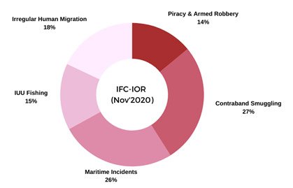
Figure 1: IFC-IOR MARSEC Report Nov’2020
IFC-IOR’s monthly Maritime Security(MARSEC) Report[iii] for the month of Nov’2020 reported 192 maritime security events in the following categories:
- Piracy and Armed Robbery
- Maritime Terrorism
- Contraband Smuggling
- Illegal Unreported Unregulated (IUU) Fishing
- Natural Events
- Irregular Human Migration
- Maritime Incidents
- Environmental Security
As per the Report, the third of all incidents composed of maritime incidents, followed by contraband smuggling, irregular human migration, IUU fishing and piracy & armed robbery. A month-on-month analysis observes that IUU fishing saw 25% decrease, but 45% increase in incidents of poaching (reported off Djibouti, India, Indonesia, Malaysia, Maldives, Pakistan, Sri Lanka, Tanzania, Thailand and Yemen).
Modern Marine Technological Trends
Ships at sea have always been early adopters of the latest technologies, be it for safe navigation or for communication with the shore. The Safety of Life at Sea (SOLAS) Convention is one of the important international treaties regarding the safety of merchant ships. The need arises to take support of the technology to create persistent sector surveillance capabilities with techniques like AIS (Automatic Information System) or the equivalent systems for smaller than SOLAS boats or, Multi-platform Data Fusion etc. The use of such hi-tech systems enhances the global Maritime Domain Awareness, thereby improving the marine security, safety and environment. Some of the evolving technologies in maritime domain are:
- Space based Automatic Identification System (SAT-AIS). As per IMO, the Automatic Identification System (AIS) for maritime safety and vessel traffic system is mandatory for ships as per their qualification criterion. The AIS broadcast utilise Very High Frequency (VHF) band of frequencies to transmit their position reports along with short messages describing ship and its voyage. Even though ship-to-ship and ship-to-ashore communications exists, however, a need for global AIS coverage was required for areas beyond frequency range. To overcome this, a space-based AIS receiver in low earth orbit has been developed and the system successfully made operational. Satellite-based AIS (SAT-AIS) makes it possible to track AIS fitted seafaring vessels beyond the coastal areas. This makes it possible now for a large-area ocean surveillance with AIS messages retransmitted by the satellites to the earth stations and AIS information shared amongst the member nations. The space based AIS can provide nearly hundred percent ship detection probability, with capacity to report thousand ships in a particular coverage area. The use of software-defined technology in the Space based AIS receivers allows for a full in-orbit re-configurability i.e., with this technique a mission can evolve throughout its lifetime. Some of the SAT-AIS primary beneficiaries shall be:
- IFC-IOR and IMAC. Vessel traffic and navigation monitoring and Maritime security services
- Coast Guard. For anti-piracy, IUU fishing and compliance of various national and international Regulations
- SAR (Search and Rescue) operations at sea.
- MARPOL Compliance. Monitoring and enforcement of pollution control regulations at sea, dangerous and hazardous cargos monitoring.
- Commercial fleet management companies
- Maritime Cloud Network. VHF Data Exchange System (VDES) is a radio frequency based communication network for information transmission between ship-to-ship, ship-to-shore and AIS satellites. The VDES optimises the use of RF spectrum by sending higher rate data along with AIS data. The VDES network protocol assists in the e-Navigation using a Maritime Cloud by utilising the Marine Mobile VHF band. The AIS is a component of VDES which uses advanced technique of Gaussian Minimum Shift Keying (GMSK) modulation.
- Multi-Platform Multi Sensor Data Fusion (MPMSDF). The sea is a highly dynamic environment and to garner any strategic maritime information, multi-sensor data fusion is undertaken to create a maritime Situational Awareness. This helps to pass on a workable maritime intelligence to the Navy and the Coast Guard. To achieve the data fusion, following sources of information are utilised:
- Marine AIS
- Coastal radars
- HF/VUHF communications
- Beacons
- Satellite Communication (Voice and Data)
- VSAT terminals
- Web and Social Media
The target data received from heterogenous sources like radars, AIS etc. from various sea going platforms are correlated and fused as per the principles of Multi-platform Multi-sensor Data Fusion (MPMSDF) system. The MPMSDF data enhances the detection capability and assist in early identification of any suspicious or threatening target(s) at sea.
(d) Artificial Intelligence (AI). Despite best of the weather forecast systems in place, the situation for ships on water is always evolving. An example is the recent unfortunate incident of Japanese ONE Apus resulting in about 2,000 containers lost or damaged in the Pacific Ocean.[iv] Predicting the weather at sea is extremely challenging for meteorological department due to rapidly evolving dynamic conditions in the ocean environment. For example, a decade long study (1999-2019)[v] on the cyclones in the month of November in the Indian region highlighted that cyclones usually deviate from the expected tracks. This is due to multiple factors affecting the cyclone path, like steering jet currents etc. With multiple Space based weather measurements, some improvements have been made in the weather prediction to forecast timely warnings. However, the use of Artificial Intelligence models has been effectively leveraged to make a more accurate weather prediction map.
(f) Industry 4.0. Industry 4.0 or the fourth industrial revolution too shall be part of marine industry and applicable to real world design, construction and operation segments. Industry 4.0 comprises of smart sensors, networked technology (IT/IoT), intelligent data analysis, AI, Augmented and Mixed Reality (AR/MR) to achieve higher efficiencies and making operations fully autonomous. Ports and terminals are undergoing a digital transformation and shall further imbibe Industry 4.0 practices. Global Supply Chain integration with Ports shall see newer state of the art emerging technologies leading to smart ports or Ports 4.0. Developments in the Industry 4.0 shall be directly applicable to Shipping 4.0 and large scale fleet performance monitoring shall be part of this initiative. Government of India has setup SAMARTH Udyog Bharat 4.0 (Smart Advanced Manufacturing and Rapid Transformation Hubs) under Department of Heavy Industries, Ministry of Heavy Industries and Public Enterprises to provide an impetus to Industry 4.0 initiative.
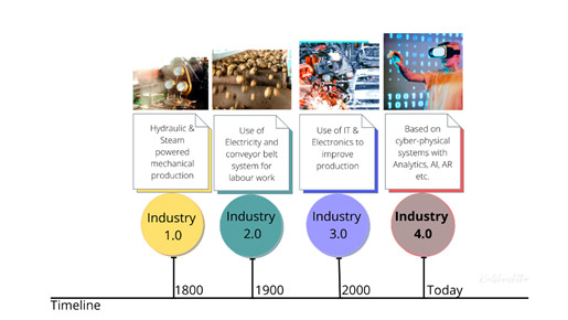
Figure 2: Industry 4.0 Evolution
(g) Cyber Security. On 01 Jan’2021, IMO’s latest requirements for integrating cyber risk into onboard Safety Management systems came into force[vi]. IMO adopted Resolution MSC.428 (98) which refers to a ship’s Safety Management System (SMS) accounting for the cyber risk management in compliance with the Information Security Management code. IMO has provided guidelines based on cyber security framework to identify and detect risks, protecting assets, responding to risk and recovering from cyber-attacks. The additional Class notations pertaining to Cyber Managed and Cyber Secure too may be assigned to ships or offshore units since maritime industry shall remain a target of cyber-criminals in 2021.
Conclusion
The sustenance and growth of the blue economy for India shall always be highly dependent upon the safety and security ensured over the high seas. In today’s geo-political situation, the blue economy’s security is also closely tied to a nation’s sovereignty. To achieve security over the vast open oceans, the technological innovations shall be the way ahead. These innovations may be in the form of incremental improvements from within marine industry, or a major disruptive change imposed due to land-based technological transformations. Further, the implementation of these contemporary technologies themselves shall enable launch of multiple latent marine technologies like autonomous cargo vessels, cyber-physical evolution for robotics onboard vessels and in the ports etc.
Author Brief Bio: Milind Kulshreshtha is a former Naval Officer who is a C4I expert and a Strategic Analyst. He has an expertise in the Joint Warfare C4I algorithms pertaining to Threat Assessment & Warfare modules, Multi-platform Multi-sensor Data Fusion (MPMSDF), and has a keen interest in Air Defence and Space Command.
[i] http://sagarmala.gov.in/about-sagarmala/background
[ii] https://pib.gov.in/PressReleasePage.aspx?PRID=1640178
[iii] https://www.indiannavy.nic.in/ifc-ior/IFC_IOR_MMSU_Nov_20.pdf
[iv] Aaron Sheldrick, “Container ship loses nearly 2,000 cargo carriers in Pacific storm”, Reuters, Dec 4, 2020, https://www.reuters.com/article/us-china-shipping-container-accident/container-ship-loses-nearly-2000-cargo-carriers-in-pacific-storm-idUSKBN28E0T7?edition-redirect=in
[v] https://www.indiannavy.nic.in/ifc-ior/Cyclone_Study.pdf
[vi] https://marine-offshore.bureauveritas.com/magazine/imo-2021-puts-spotlight-cyber-security