
Separated by over 1,300 km from the mainland, the Andaman and Nicobar Islands have long been considered a potential strategic outpost for India. However, their true strategic importance has only recently come into focus. This paper analyses the significance of the Andaman and Nicobar Islands for India and the current status of developmental activities to maximise their potential.
Geography and Its Impact on India’s National Strategy
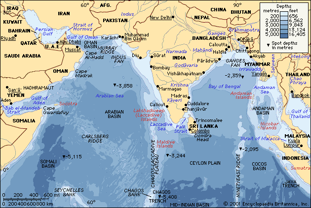
Geography studies the Earth’s surface, physical features, location, size and shape, natural resources, and climate. It significantly influences a nation’s strategy across its political, economic, security, and diplomatic spheres. The unique character of the geographical entity of India includes vast expanses of land, snow-covered mountains, plains, deserts, an extended coastline, and islands. It is the seventh largest country in the world, with land boundaries of over 15000 km. India shares maritime borders with five countries. Its total coastline is 7,516 km long, comprising 5,422 km for the mainland, 132 km for the Lakshadweep Islands, and 1,962 km for the Andaman and Nicobar Islands. The Indian peninsula extends 1,980 km into the Indian Ocean.
Fifty percent of the Indian Ocean basin lies within a 1,500 km radius of India, a fact that has strategic implications. India possesses 1,197 islands in the Indian Ocean, which include 836 islands, islets, and rocky outcrops in the Andaman and Nicobar Islands—31 of these are inhabited—and 23 in Lakshadweep, with 10 being inhabited. Additionally, there are 447 islands off the western coast and 151 islands off the eastern coast. The extensive coastline affords India significant strategic access to vital sea routes, enabling monitoring and controlling of major chokepoints such as the Strait of Malacca while ensuring freedom of navigation in the Indo-Pacific region. It also facilitates strategic engagements with its Southeast Asian neighbours through the Act East Policy to counter China’s influence and foster closer ties with Middle Eastern nations for energy security on the western front. These diverse geographical features have shaped India’s defence policies, economic development, and international relations.
Geography, therefore, is highly significant in international relations and plays a vital role in shaping world order. It serves multiple functions, such as establishing sovereignty, maintaining peace and security, facilitating effective governance, and allowing a country to exert global influence in shaping foreign policy, defence strategies, and control over natural resources.[1]
Current Global Order
The current global order is fragile and transforming at a remarkable pace. It is becoming more complex and dangerous than ever. Ever-changing geopolitical dynamics, economic realignments, and emerging challenges mark this landscape. The geopolitical churn in the Indian Ocean Region has escalated to a feverish pitch. Four major evolving geopolitical dynamics currently reshaping the global order include the following:
- Transition from a unipolar world dominated by the US to a multipolar world in which China, Russia, the EU, and regional powers play significant roles.
- The ongoing conflict between Russia and Ukraine is resulting in sanctions and geopolitical tensions.
- The Israel-Palestine conflict is causing realignments in the Middle East.
- The strategic competition between the US and China makes the Indo-Pacific region a geopolitical and economic centre of gravity.
These geopolitical developments hinder the world’s ability to establish a stable, inclusive, and peaceful global order that could promote inclusive growth and collaboratively tackle shared threats such as climate change.
The Indo-Pacific Region
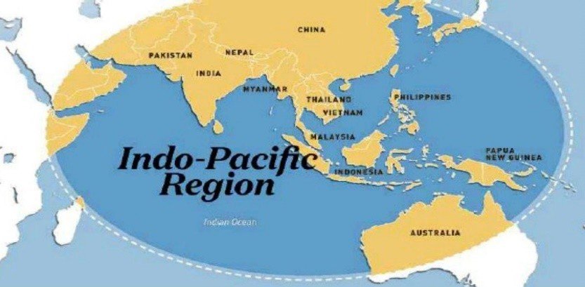
The Indo-Pacific region refers to the vast geographic area extending from the east coast of Africa to the western coast of the Americas, encompassing the Indian Ocean and the western and central Pacific Ocean, including the seas and straits that connect them. The term “Indo-Pacific” has gained prominence in recent years, particularly in geopolitical discussions and regional security strategies. It is home to major economies, including China, India, Japan, the ASEAN nations, and Australia. The region is home to 65% of the world’s population and accounts for 63% of the world’s GDP. Additionally, 40% of global trade passes through the South China Sea[2]. It is fast developing into the world’s centre of gravity.
Major challenges faced by the region include the complex power dynamics stemming from economic difficulties, environmental issues, and non-traditional security threats. China’s rapid economic and military growth, maritime disputes in the South China Sea, and competing interests of the US, China, and regional powers are creating a shift in global attention towards the Indo-Pacific. Amongst the major powers, the US, China, India, the UK, and Australia all have a naval presence in the region. Over the years, several alliances and regional organisations have been established to counter the ever-expanding Chinese influence in the area. Some of the most significant are the QUAD (Quadrilateral Security Dialogue – US, India, Japan, and Australia), ASEAN (Association of Southeast Asian Nations), and RCEP (Regional Comprehensive Economic Partnership). The US, India, Japan, and Australia advocate for a Free and Open Indo-Pacific (FOIP).
In relation to India in the Indo-Pacific, China’s increasing influence has led it to engage with various friendly nations and emerging partners pragmatically. Its approach in the Indo-Pacific is built upon four pillars:
- Collaboration to address shared concerns.
- Avoid ‘alliances of containment’ – do not compel others to choose sides.
- Embrace evolution rather than revolution in regional order.
- Recognising regional institutions and groupings as a crucial foundation for the future order.[3]
In the 21st century, the Indo-Pacific has become a pivotal region in the changing world order. Here, economic interdependence coexists with geopolitical tensions. The region’s stability will depend on how major powers manage competition and cooperation.
Indian Ocean Region

The vast geographical region of the Indian Ocean Region (IOR) extends from the west coast of Africa to Antarctica in the south and the Southeast Asian Region in the east. It connects the Persian Gulf, the Suez Canal, and the Strait of Malacca, establishing itself as a crucial maritime highway for international trade. The Indian Ocean has three main choke points: the Strait of Malacca in the east and the Strait of Hormuz and Bab el-Mandeb in the west. The blockage of any of these would disrupt seaborne trade and lead to uncontrolled volatility in oil and commodity prices, resulting in upheavals in the global economy. In this strategically significant region of the IOR, India is situated at the tri-junction of Western, Southern, and Southeast Asia. It enjoys strategic centrality, dominating the IOR and its Sea Lines of Communication (SLOCs), making it the largest stakeholder in the region[4]. “India is at the crossroads of the Indian Ocean…We will be more dependent than before on the ocean and surrounding regions. We must also assume our responsibility to shape its future,” Prime Minister Narendra Modi declared in a speech in Mauritius in 2015.[5] Today, the IOR remains vital to the security and stability of shipping lanes and trade routes, representing over one-third of the world’s bulk cargo traffic and two-thirds of the world’s oil shipments, thereby ensuring global access to food, precious metals, and energy resources.[6]
China’s Malacca Dilemma, a term coined in 2003 by then President Hu Jintao, signifies the potential factors that could impede its economic development by restricting oil imports. The strategic position of the Strait of Malacca, located between the Sumatra Islands and the Malay Peninsula, with Singapore to its east, could be easily obstructed by rival nations of China, impacting the transportation of 80 per cent of its oil imports trade.[7] Despite the increasing power of China and its endeavours to secure military access and bases, gain support from partner countries, establish alternative routes, and enhance its naval capabilities, the Malacca Dilemma persists in a hypothetical wartime scenario.[8] China’s ‘Malacca Dilemma’ also centres on the United States expanding its military presence in China’s periphery, particularly in the Indian Ocean Region, and developing closer relations with countries like India, which reinforce US naval capabilities to exert complete control over China’s access to Indian Ocean sea lanes. Over the years, such assessments have become a critical trigger for China’s naval expansion initiatives.[9] In the face of these perceived threats, China feels isolated and targeted. It is pursuing alternative supply routes around Malacca through overland infrastructure projects that connect inland Chinese cities to ports in Pakistan and Myanmar. However, despite these diversification attempts, China will remain dependent on the Strait of Malacca in the short term.
An economically and militarily buoyant China is therefore looking beyond its regional influence to enhance its presence in the Indian Ocean Region and further afield through these strategic choke points. It is leveraging its economic and military power, along with the advantages that come with them, to achieve its security and strategic goals in the IOR. A significant threat in the Indian Ocean region is the rapidly growing importance of the Indian Ocean in Chinese security policies, which view this area as part of their intended sphere of influence.
Aside from SLOC dependency, China has also attempted to project power ‘in’ and ‘from’ the Indian Ocean. The expanse of China’s maritime silk route (as a component of the Belt and Road Initiative) and its strategic implications, its search for overseas military bases with Djibouti as one, its interest in protecting supply lines for commercial and military interests to Africa, West Asia and beyond, the movements of submarines, and the modernisation of its navy with warships capable of operating in the Indian Ocean – all contribute to significant unease in India-China relations. The emergence of China, not only as an economic power but also as a military power, disrupting maritime equations and the balance of power, is the dominant narrative of the 21st century. China views the Indian Ocean Region as its arena of strategic dominance, where its economic relationships are intended to be articulated based upon military power projection. However, the concern that causes India to be wary of China’s Indian Ocean aspirations lies in the intentions, as well as the means and methods that China employs to establish its ‘presence’ in this expanse of the Asiatic lifeline.
Within the context of the deteriorating maritime situation in the Asia-Pacific region—mainly due to tensions in the South China Sea, the power play between the US and China, and the growing Chinese maritime capabilities—conditions of heightened insecurity among the region’s littorals could arise over time. From the Indian perspective, Chinese attempts to dominate the maritime space in the Indian Ocean Region through increasing forays, establishing base facilities, and courting the IOR littorals for operational turnaround facilities could eventually pose a challenge to India’s island territories near the straits. However, the choke points near the Andaman and Nicobar Islands make these islands sentinels or gateways to this oceanic highway and resource-rich area, as they sit astride the SLOCs.
Andaman and Nicobar Islands and Their Locations
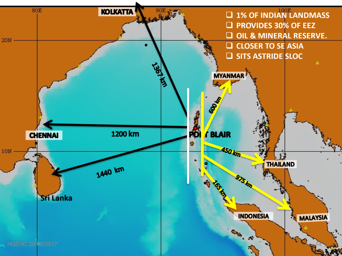
The Andaman and Nicobar Islands are an archipelagic chain of 836 islands, islets, and rocky outcrops, of which only 31 are inhabited. They extend over 720 km in the southeastern Bay of Bengal. This chain of islands is oriented geographically in a north-south direction and is divided into two main groups, namely the Andaman and Nicobar groups. The Northern Group of Islands (NGI) and the Southern Group of Islands (SGI) are separated by the Ten Degree Channel, which is 80 nautical miles wide. The Southern Group is further divided into three main groups: Carnicobar (CARNIC), the Nancowry Group, and Great Nicobar Islands (GNI). A coastline of 1,692 km grants these islands an Exclusive Economic Zone of 663,629 square kilometres and a terrestrial land area of 8,249 square kilometres. Thus, despite these islands constituting less than 1% of the mainland landmass, they provide over 30% of India’s Exclusive Economic Zone, presenting tremendous potential for mining undersea resources, which are crucial to the nation’s economy.
Indira Point in GNI overlooks the crucial Six Degree Channel, the SLOC for all significant maritime activity. Its northernmost tip, i.e., the Landfall Islands, is only 40 km from the Coco Islands (Myanmar). Indira Point, formerly known as Pygmalion Point, located at the southern tip, is about 165 km from Indonesia. The islands lie approximately 450 km northwest of Phuket in Thailand and 975 km northwest of Kuala Lumpur in Malaysia. Essentially, the Andaman Islands are closer to these littoral countries than the Indian mainland. Their location astride the strategic SLOCs leading to the Malacca Straits provides India with a strategic overview of the shipping traffic in the IOR.
Strategic Significance of Andaman and Nicobar Islands
As the sole archipelago in the Bay, striding important Sea Lines of Communication and overlooking the Malacca Strait, the Andaman and Nicobar Islands are of utmost importance for India’s strategic interests.[10] Situated closer to Southeast Asian countries, these islands extend India’s security perimeter eastwards, providing exceptional defence in depth. Positioned astride the strategic SLOCs leading to the Malacca Strait, they also offer India a strategic vantage point over the shipping traffic in the Indian Ocean Region, facilitating Indian dominance not only over the Bay of Bengal but also over the Six and Ten-Degree Channel, as well as the entry and exit to the Malacca Strait. The capacity to monitor Chinese maritime activity in the Indian Ocean Region through these islands allows India to gather valuable information regarding the nature and intent of Chinese forces. By using these islands as the maritime pivot, the Indian Navy can counter any incursions by the People’s Liberation Army Navy’s (PLA(N)) surface combatants, aircraft carriers, or strategic submarines (SSNs/SSBNs) entering the Indian Ocean Region (IOR). These islands enhance India’s strategic frontiers and make them a valuable asset for India to extend its “Act East Policy.” Their proximity to Southeast Asian countries could be exploited to facilitate fruitful engagements with them and foster friendly relations.[11]
Current Status of Developmental Activities
Following the Kargil Conflict in 1999, based on the recommendations of the Kargil Review Committee, the Group of Ministers approved the establishment of an integrated command in May 2001. Consequently, the Andaman and Nicobar Command (ANC), the first and only unified operational command, was raised in October 2001. The ultimate aim of establishing this command was to promote jointmanship among the services within the unique operational environment of these islands. The role of the ANC encompasses the “Defence of the Andaman and Nicobar Islands,” including its waters, airspace, humanitarian assistance, disaster relief, and the protection of future offshore installations when they are established.[12] The ANC has continuously extended its Defence Diplomacy through coordinated patrol exercises (CORPATs) with nearly all its neighbouring countries on a biannual basis, resulting in excellent synergy with the littoral navies. Over the past 24 years, the command has expanded in terms of assets and manpower, thus enhancing its capability. However, progress has been modest compared to the roles and tasks allotted to it.
In recent years, the realisation of the strategic potential of these islands and the increased national interest in strengthening ties with Southeast Asia have prompted the current government to seek a strategy that would rationalise strategic and economic growth with environmental protection to ensure “all-round national development.”[13] By utilising the Act East Policy, India is focusing on the holistic development of these islands through a combination of strategic investments and increasing military strength in the Andaman and Nicobar Islands. Development projects include modernised airfields, expanded jetties, enhanced logistics and storage facilities, upgraded troop accommodations, and advanced surveillance assets. India aims for these islands to serve as a force multiplier in the larger Indo-Pacific region. Strengthening defence infrastructure on the islands would send a strong message that India intends to remain the leading player in the Indian Ocean.
The ambitious Great Nicobar Island project, situated at the southernmost tip of Indian territory and just 80 nautical miles from the northernmost island of Indonesia, is now awaiting final Cabinet approval following the receipt of all necessary environmental clearances. Estimated to cost ₹1 lakh crore over two phases, the project comprises four main components: the development of an International Container Transshipment Terminal (ICTT) at Galathea Bay, a greenfield international airport, an integrated township, and a gas and solar-based power plant on the island. The vision for the ICTT is to position the island as a key player in the regional and global maritime economy of cargo transshipment. Moreover, the Andaman and Nicobar administration has signed a 30-year Memorandum of Understanding with Cochin Shipyard Ltd (CSL) to upgrade ship and boat repair yards within the island territories. Once operational, these yards will save shipping companies a costly trip to Chennai, Visakhapatnam, or Kolkata for repairs.[14]
Conclusion
The Andaman and Nicobar Islands’ geographical location, straddling the Malacca Strait’s choke point and lying over 1200 km from the mainland while stretching over 750 km from north to south, makes them a valuable geopolitical asset. They play a crucial role in the region’s maritime competition of the 21st century. These islands hold the potential for development to further India’s rising economic, political, and military interests in the Asia-Pacific, especially as China becomes increasingly active in the Indian Ocean Region. Enhancing their considerable economic and military potential can add strategic weight to India’s posture, and the deterrence value that these islands can provide will be significant.[15] The current focus, therefore, is on enhancing the surveillance and deterrence value of these islands through various infrastructure development, positioning military assets on the islands, enhancing communication and establishing a comprehensive economic and military engagement with the littorals. India’s strategic development of these islands is not just a defensive measure but a clear message of resolve in safeguarding its maritime interests and regional stability.
Author Brief Bio: Air Marshal PK Roy, PVSM, AVSM, VM, VSM, is a former Commandant of the National Defence College, New Delhi and the former Commander-in-Chief of the Andaman and Nicobar Command.
References:
[1] https://theflags.org/geography-and-the-role-of-boundaries-in-international-relations/?utm_source=chatgpt.com#google_vignette
[2] https://vajiramandravi.com/quest-upsc-notes/indo-pacific-region/
[3] ‘Walter Ladwig’, The Indo-Pacific in Indian Foreign Policy, https://rusi.org/explore-our-research/publications/policy-briefs/indo-pacific-indian-foreign-policy
[4] Strategic Vision –2030 Security and Development of Andaman & Nicobar Islands, Air Marshal PK Roy and Commodore Aspi Cawasji, Vij Books India Pvt Ltd, ISBN 978-93-86457-18-9 (Hardback)
[5] Text of PM’s Remarks on the Commissioning of Coast Ship Barracuda, 12 March 2015, https://www.pmindia.gov.in/en/news_updates/text-of-the-pms-remarks-on-the-commissioning-of-coast-ship-barracuda/
[6] “About IORA,” Indian Ocean Rim Association Online, accessed on 9 February 2025 February 2025, https://www.iora.int/en/about/about-iora .
[7] ‘Navya Mudunuri’, The Malacca Dilemma and Chinese Ambitions: Two Sides of a Coin, https://diplomatist.com/2020/07/07/the-malacca-dilemma-and-chinese-ambitions-two-sides-of-a-coin/
[8] ‘Malacca Dilemma’ a major security challenge for PRC, https://ipdefenseforum.com/2023/10/malacca-dilemma-a-major-security-challenge-for-prc/
[9] ‘Swaran Singh’, China’s forays into the Indian Ocean: Strategic implications for India, Journal of the Indian Ocean Region December 2011
[10] ‘Sohini Bose & Anasua Basu Ray Chaudhury’ The Andaman and Nicobar Islands: Indian Territory, Regional Potential https://www.orfonline.org/research/the-andaman-and-nicobar-islands-indian-territory-regional-potential Accessed on 10 February 2025
[11] India – the bridge linking South and Southeast Asia, https://www.orfonline.org/research/india-the-bridge-linking-south-and-southeast-asia
[12] Strategic Vision –2030 Security and Development of Andaman & Nicobar Islands, Air Marshal PK Roy and Commodore Aspi Cawasji, Vij Books India Pvt Ltd, ISBN 978-93-86457-18-9 (Hardback)
[13] Government of India, “Study Group Report on Comprehensive and Sustainable Development of the Andaman and Nicobar Islands”
[14] ‘Nitin A Gokhale’ Green Knots Ironed Out, Great Nicobar Island Project Awaits Centre’s Final Clearance, https://bharatshakti.in/green-knots-ironed-out-great-nicobar-island-project-awaits-centres-final-clearance/ Accessed on 31 January 2025
[15] ‘Muraliprasath P’, Role of Andaman and Nicobar Islands in the Indo-Pacific: India’s Eastern Anchor, https://www.ejsss.net.in/article_html.php?did=9675&issueno=0